Cape Foulweather to Yaquina Bay, August 12th 2007.
Click on the small image to see the full-sized one.
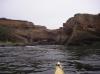
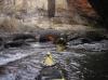
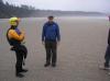
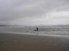
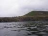
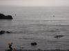 Surfers paddle up to Dick Ryon in the morning
Links to related images: Nearby. Proofs. Map.
Approximate location: 44.76244N / 124.06734W.
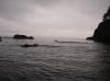
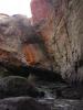
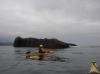
 Dick Ryon rock gardening around Otter Crest
Links to related images: Nearby. Proofs. Map.
Approximate location: 44.76244N / 124.06734W.
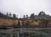 Buildingss between Otter Crest and Devils Punch Bowl
Links to related images: Nearby. Proofs. Map.
Approximate location: 44.74813N / 124.06579W.
 Devils Punch Bowl at low tide
Links to related images: Nearby. Proofs. Map.
Approximate location: 44.74789N / 124.06611W.
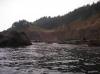
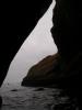
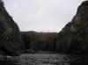
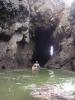
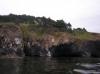
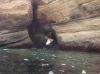 Entering Devils Punch Bowl
Links to related images: Nearby. Proofs. Map.
Approximate location: 44.74693N / 124.06551W.
 People looking down at us inside Devils Punch Bowl
Links to related images: Nearby. Proofs. Map.
Approximate location: 44.74843N / 124.06489W.
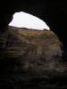
 Inside Devils Punch Bowl
Links to related images: Nearby. Proofs. Map.
Approximate location: 44.74843N / 124.06489W.
 Dick Ryon inside Devils Punch Bowl
Links to related images: Nearby. Proofs. Map.
Approximate location: 44.74843N / 124.06489W.
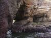
 Inside Devils Punch Bowl
Links to related images: Nearby. Proofs. Map.
Approximate location: 44.74639N / 124.06562W.
 South side of Devils Punch Bowl
Links to related images: Nearby. Proofs. Map.
Approximate location: 44.74551N / 124.06459W.
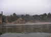 Calm beach south of Devils Punch Bowl
Links to related images: Nearby. Proofs. Map.
Approximate location: 44.74525N / 124.06455W.
 Dick Ryon and Dave Harry at Devils Punch Bowl
Links to related images: Nearby. Proofs. Map.
Approximate location: 44.74504N / 124.06423W.
 Dave Harry and Steve at Devils Punch Bowl
Links to related images: Nearby. Proofs. Map.
Approximate location: 44.74504N / 124.06423W.
 Surfer teaching a dog to surf
Links to related images: Nearby. Proofs. Map.
Approximate location: 44.74626N / 124.06255W.
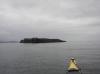 Otter Rock
Links to related images: Nearby. Proofs. Map.
Approximate location: 44.7336N / 124.07051W.
 Dick Ryon at Otter Rock
Links to related images: Nearby. Proofs. Map.
Approximate location: 44.73335N / 124.07081W.
 Approaching Yaquina Head
Links to related images: Nearby. Proofs. Map.
Approximate location: 44.6815N / 124.07382W.
 North side of Yaquina Head
Links to related images: Nearby. Proofs. Map.
Approximate location: 44.6773N / 124.07721W.
 Small cove in north side of Yaquina Head
Links to related images: Nearby. Proofs. Map.
Approximate location: 44.67726N / 124.07744W.
 Slot in cliff at Yaquina Head
Links to related images: Nearby. Proofs. Map.
Approximate location: 44.67689N / 124.07747W.
 Hikers lookin down from Yaquina Head at us in slot
Links to related images: Nearby. Proofs. Map.
Approximate location: 44.67689N / 124.07747W.
 Dave Harry exiting slot in Yaquina Head
Links to related images: Nearby. Proofs. Map.
Approximate location: 44.6773N / 124.07734W.
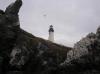 Lighthouse at Yaquina head
Links to related images: Nearby. Proofs. Map.
Approximate location: 44.67788N / 124.07935W.


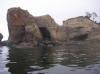
 Incredible rocks at tip of Yaquina Head
Links to related images: Nearby. Proofs. Map.
Approximate location: 44.67702N / 124.0797W.
 Dick Ryon under the Yaquina Lighthouse
Links to related images: Nearby. Proofs. Map.
Approximate location: 44.67702N / 124.0797W.
 Cave too low to go under at Yaquina Head
Links to related images: Nearby. Proofs. Map.
Approximate location: 44.67698N / 124.08015W.
 Dave Harry rock gardening Yaquina Head
Links to related images: Nearby. Proofs. Map.
Approximate location: 44.67672N / 124.08021W.
 Incredible rocks at tip of Yaquina Head
Links to related images: Nearby. Proofs. Map.
Approximate location: 44.67646N / 124.0809W.
 Dick Ryon under the Yaquina Lighthouse
Links to related images: Nearby. Proofs. Map.
Approximate location: 44.67597N / 124.08101W.
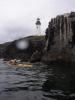
 Lighthouse at Yaquina head
Links to related images: Nearby. Proofs. Map.
Approximate location: 44.67363N / 124.07929W.
 Stairs down to beach at Yaquina Head
Links to related images: Nearby. Proofs. Map.
Approximate location: 44.67363N / 124.07929W.
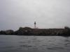
 Lighthouse at Yaquina head
Links to related images: Nearby. Proofs. Map.
Approximate location: 44.67279N / 124.07532W.
 Hikers at the quarry tidepool at Yaquina Head
Links to related images: Nearby. Proofs. Map.
Approximate location: 44.67361N / 124.07277W.
 Last small caves at Yaquina Head
Links to related images: Nearby. Proofs. Map.
Approximate location: 44.67324N / 124.06976W.
 Dave Harry admires the basalt of Yaquina Yead
Links to related images: Nearby. Proofs. Map.
Approximate location: 44.67299N / 124.0691W.
 Looking back at Yaquina Head
Links to related images: Nearby. Proofs. Map.
Approximate location: 44.66367N / 124.06847W.
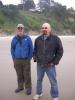
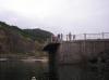
 Christine Hauser, Dave Harry and Dick Ryon at the Yaquina Bay jetty
Links to related images: Nearby. Proofs. Map.
Approximate location: 44.61213N / 124.07249W.
 We set up the rain tarp since we had guests for dinner
Links to related images: Nearby. Proofs. Map.
Approximate location: 44.61213N / 124.07249W.
 Christen stopped to ask us questions about kayaking
Links to related images: Nearby. Proofs. Map.
Approximate location: 44.61213N / 124.07249W.
 Sunset over the Yaquina Bay jettys
Links to related images: Nearby. Proofs. Map.
Approximate location: 44.61213N / 124.07249W.
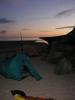
 Our campsite next to the Yaquina Bay south jetty
Links to related images: Nearby. Proofs. Map.
Approximate location: 44.61213N / 124.07249W.
 Dick Ryon on the Yaquina Bay south jetty
Links to related images: Nearby. Proofs. Map.
Approximate location: 44.61213N / 124.07249W.
 Our campsite next to the Yaquina Bay south jetty
Links to related images: Nearby. Proofs. Map.
Approximate location: 44.61213N / 124.07249W.
 Sophie and her dad asked us questions about kayaking
Links to related images: Nearby. Proofs. Map.
Approximate location: 44.61213N / 124.07249W.
All text and images Copyright © 2007 by Mike Higgins / contact