Yaquina Bay to Neptune State Park, August 13th 2007.
Click on the small image to see the full-sized one.
 Dick Ryon starts the long haul to the water in the morning
Links to related images: Nearby. Proofs. Map.
Approximate location: 44.61089N / 124.075W.
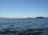
 The tide dropped 10 feet on this morning
Links to related images: Nearby. Proofs. Map.
Approximate location: 44.60775N / 124.07809W.

 Dick Ryon launching behind the Yaquina Bay south jetty
Links to related images: Nearby. Proofs. Map.
Approximate location: 44.60775N / 124.07809W.


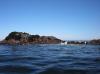 Offshore rocks near Seal Rock State Wayside
Links to related images: Nearby. Proofs. Map.
Approximate location: 44.50486N / 124.0924W.
 Seal Rock State Wayside looks interesting
Links to related images: Nearby. Proofs. Map.
Approximate location: 44.48881N / 124.09482W.
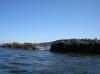
 We aproach Seal Rock State Wayside
Links to related images: Nearby. Proofs. Map.
Approximate location: 44.48881N / 124.09482W.


 Rocks mixed with sand at Seal Rock State Wayside
Links to related images: Nearby. Proofs. Map.
Approximate location: 44.48673N / 124.08637W.
 Dick Ryon rock gardening at Seal Rocks
Links to related images: Nearby. Proofs. Map.
Approximate location: 44.48523N / 124.08689W.

 Dick Ryon chasing whales
Links to related images: Nearby. Proofs. Map.
Approximate location: 44.38189N / 124.09918W.

 I was less than 20 feet from this gray whale!
Links to related images: Nearby. Proofs. Map.
Approximate location: 44.3759N / 124.10038W.


 Houses at the town of Yachats
Links to related images: Nearby. Proofs. Map.
Approximate location: 44.29286N / 124.11467W.
 Cave south of Yachats
Links to related images: Nearby. Proofs. Map.
Approximate location: 44.28797N / 124.11527W.

 Devils Churn from the outside
Links to related images: Nearby. Proofs. Map.
Approximate location: 44.28411N / 124.11257W.
 Highway 101 bridge near Devils Churn
Links to related images: Nearby. Proofs. Map.
Approximate location: 44.27737N / 124.1153W.
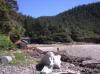
 Our kayaks landed at Cummins Creek
Links to related images: Nearby. Proofs. Map.
Approximate location: 44.26572N / 124.10869W.
 Dick Ryon looking for a place to camp at Cummins Creek
Links to related images: Nearby. Proofs. Map.
Approximate location: 44.26572N / 124.10869W.
All text and images Copyright © 2007 by Mike Higgins / contact