Mike's Kayak Journal, all photos taken on 2007-09-23
Click on the small image to see the full-sized one.
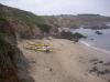
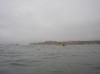
 Our kayaks in Whalers Cove at the Pigeon Point Lighthouse
Links to related images: Nearby. Proofs. Map.
Approximate location: 37.1828732245943N / 122.39245355129W.
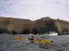
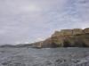
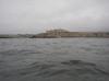
 Limestone cliffs and caves south of Half Moon Bay
Links to related images: Nearby. Proofs. Map.
Approximate location: 37.370088971729N / 122.4107837677W.
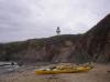
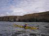
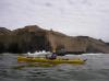 Gregg Berman in front of limestone cliffs and caves south of Half Moon Bay
Links to related images: Nearby. Proofs. Map.
Approximate location: 37.3784104180167N / 122.41387367249W.
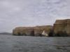
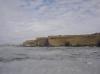
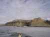
 Limestone cliffs and caves south of Half Moon Bay
Links to related images: Nearby. Proofs. Map.
Approximate location: 37.3834574028377N / 122.41704940796W.
 Gregg Berman in front of limestone cliffs and caves south of Half Moon Bay
Links to related images: Nearby. Proofs. Map.
Approximate location: 37.3859807678714N / 122.41876602173W.
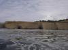
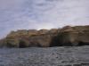
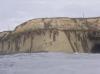 Limestone cliffs and caves south of Half Moon Bay
Links to related images: Nearby. Proofs. Map.
Approximate location: 37.3906180821565N / 122.42228507996W.
 Gregg Berman near Eel Rock
Links to related images: Nearby. Proofs. Map.
Approximate location: 37.3928002484491N / 122.42365837097W.
 The fancy hotel south of Half Moon Bay
Links to related images: Nearby. Proofs. Map.
Approximate location: 37.425525119226N / 122.44365692139W.
 Michael Powers with impliment of hedge destruction
Links to related images: Nearby. Proofs. Map.
Approximate location: 37.4936177018398N / 122.46024370193W.
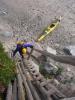 Gregg Berman climing up Michael Powers' kayak access
Links to related images: Nearby. Proofs. Map.
Approximate location: 37.4936177018398N / 122.46027052402W.
 Dick Ryon landed in front of Michael Powers kayak access
Links to related images: Nearby. Proofs. Map.
Approximate location: 37.4936177018398N / 122.46028125286W.
All text and images Copyright © 2007 by Mike Higgins / contact