El Puerto to La Calavera, October 12th 2007.
Click on the small image to see the full-sized one.
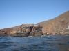
 Charles Harris at Punta Santo Tomas
Links to related images: Nearby. Proofs. Map.
Approximate location: 31.55471N / 116.67822W.
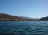
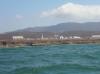
 El Puerto, the town on Punta Santo Tomas
Links to related images: Nearby. Proofs. Map.
Approximate location: 31.55477N / 116.67747W.
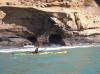
 Charles Harris doing the seal launch off Punta Santo Tomas
Links to related images: Nearby. Proofs. Map.
Approximate location: 31.55415N / 116.67749W.
 Gregg Berman doing the seal launch off Punta Santo Tomas
Links to related images: Nearby. Proofs. Map.
Approximate location: 31.55415N / 116.67749W.
 The town of La Bocana viewed from the sea
Links to related images: Nearby. Proofs. Map.
Approximate location: 31.53284N / 116.66459W.
 A limestone mine at Punta Prieta
Links to related images: Nearby. Proofs. Map.
Approximate location: 31.51422N / 116.64794W.
 The superintendent's house at the Punta Prieta limestone mine
Links to related images: Nearby. Proofs. Map.
Approximate location: 31.51422N / 116.64794W.
 A limestone mine at Punta Prieta
Links to related images: Nearby. Proofs. Map.
Approximate location: 31.51422N / 116.64794W.


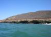
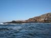
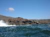
 The Rugged Pacific shore of Baja
Links to related images: Nearby. Proofs. Map.
Approximate location: 31.46632N / 116.60505W.
 Layered cliffs on the Rugged Pacific shore of Baja
Links to related images: Nearby. Proofs. Map.
Approximate location: 31.46613N / 116.60496W.
 Greg Berman in front of layered cliffs
Links to related images: Nearby. Proofs. Map.
Approximate location: 31.46253N / 116.60215W.

 The Rugged Pacific shore of Baja
Links to related images: Nearby. Proofs. Map.
Approximate location: 31.46244N / 116.60196W.
 Greg Berman in front of layered cliffs
Links to related images: Nearby. Proofs. Map.
Approximate location: 31.46197N / 116.59972W.
 Offshore rock with water pouring out cave
Links to related images: Nearby. Proofs. Map.
Approximate location: 31.46044N / 116.59691W.
 Greg Berman in front of layered cliffs
Links to related images: Nearby. Proofs. Map.
Approximate location: 31.46044N / 116.59691W.
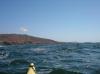
 Greg Berman approaching Punta San Jose
Links to related images: Nearby. Proofs. Map.
Approximate location: 31.46064N / 116.59571W.

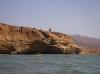
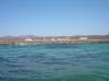
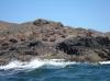
 Shoreline of Punta San Jose
Links to related images: Nearby. Proofs. Map.
Approximate location: 31.46105N / 116.5943W.
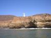
 Punta San Jose light
Links to related images: Nearby. Proofs. Map.
Approximate location: 31.46216N / 116.59099W.
 Greg Berman in front of layered cliffs
Links to related images: Nearby. Proofs. Map.
Approximate location: 31.46216N / 116.59099W.
 Punta San Jose light
Links to related images: Nearby. Proofs. Map.
Approximate location: 31.46229N / 116.58915W.
 Fish camp at Punta San Jose
Links to related images: Nearby. Proofs. Map.
Approximate location: 31.46246N / 116.58797W.
 Looking for a beach to camp on
Links to related images: Nearby. Proofs. Map.
Approximate location: 31.45954N / 116.56642W.
 Strange city built in the middle of nowhere
Links to related images: Nearby. Proofs. Map.
Approximate location: 31.41285N / 116.51299W.
 Coastline too rugged to land on
Links to related images: Nearby. Proofs. Map.
Approximate location: 31.36296N / 116.47875W.
 Gregg Berman and Charles Harris looking for a landing spot
Links to related images: Nearby. Proofs. Map.
Approximate location: 31.36296N / 116.47875W.
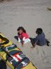

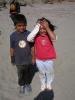 Two kids we met on the sandy beach of La Calavera
Links to related images: Nearby. Proofs. Map.
Approximate location: 31.36185N / 116.47074W.
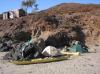 Camping on the sand at the town of La Calavera
Links to related images: Nearby. Proofs. Map.
Approximate location: 31.36195N / 116.47094W.
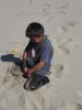
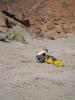 Gregg Berman setting up camp at La Calavera
Links to related images: Nearby. Proofs. Map.
Approximate location: 31.36195N / 116.47094W.
All text and images Copyright © 2007 by Mike Higgins / contact