Mike's Kayak Journal, all photos taken on 2007-11-21
Click on the small image to see the full-sized one.
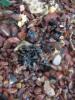 Patch of bunker oil spill on Red Rock Island
Links to related images: Nearby. Proofs. Map.
Approximate location: 37.9300834188482N / 122.43076086044W.
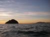 Leaving Red Rock Island in the morning
Links to related images: Nearby. Proofs. Map.
Approximate location: 37.9318435961565N / 122.43524551392W.


 The Hawaiian Chieftain motors by in the morning
Links to related images: Nearby. Proofs. Map.
Approximate location: 37.9348899572914N / 122.44807720184W.
All text and images Copyright © 2007 by Mike Higgins / contact