Angel Island New Years Eve Camping, December 31st 2007.
Click on the small image to see the full-sized one.
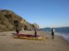 Landing on Perls Beach, Angel Island
Links to related images: Nearby. Proofs. Map.
Approximate location: 37.8549319761297N / 122.43822813034W.
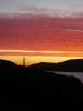
 The start of the climb from Perls Beach to ridge camp
Links to related images: Nearby. Proofs. Map.
Approximate location: 37.8551098697544N / 122.4383354187W.
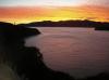

 View of the Golden Gate Bridge from Angel Island
Links to related images: Nearby. Proofs. Map.
Approximate location: 37.8657657618487N / 122.43934392929W.

 Picnic table at Ridge Camp 5, Angel Island
Links to related images: Nearby. Proofs. Map.
Approximate location: 37.8573631518436N / 122.44056433439W.
All text and images Copyright © 2007 by Mike Higgins / contact