Mini Gonzo Paddle, February 18th 2008.
Click on the small image to see the full-sized one.
 The inrepid kayaker napping near Red Rock
Links to related images: Nearby. Proofs. Map.
Approximate location: 37.93077N / 122.43112W.
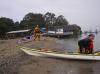
 Launching at Oh-Dark-Hundred Hours for the Mini Gonzo
Links to related images: Nearby. Proofs. Map.
Approximate location: 37.8335413752328N / 122.47429847717W.

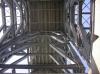
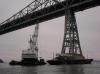 Fred Cooper examining repairs to the Richmond Bridge
Links to related images: Nearby. Proofs. Map.
Approximate location: 37.9355838330082N / 122.4467253685W.
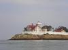
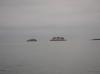 Passing The Brother Islands on the way north
Links to related images: Nearby. Proofs. Map.
Approximate location: 37.9615233139661N / 122.44537353516W.

 Stopping for lunch at China Camp halfway through the Mini Gonzo paddle
Links to related images: Nearby. Map.
Approximate location: 38.0003308173979N / 122.46085524559W.
 Gordon Schanck between The Brother Islands on the way south
Links to related images: Nearby. Proofs. Map.
Approximate location: 37.9624030313909N / 122.43443012238W.
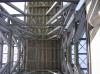
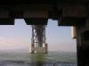 Under a tower of the Richmond / San Rafael Bridge
Links to related images: Nearby. Proofs. Map.
Approximate location: 37.9343483912052N / 122.43322849274W.
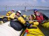
 The Intrepid Kayaker with Fred Cooper, Gordon Schanck and Dennis Holton
Links to related images: Nearby. Proofs. Map.
Approximate location: 37.83382N / 122.47052W.
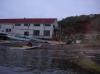
 The Intrepid Kayaker disorganizing tables at China Camp State Park
Links to related images: Nearby. Proofs. Map.
Approximate location: 37.83382N / 122.47052W.
All text and images Copyright © 2008 by Mike Higgins / contact