Gonzo 12 Island Paddle, March 9th 2008.
Click on the small image to see the full-sized one.
 Dennis Holton getting ready to launch at Horseshoe Cove
Links to related images: Nearby. Proofs. Map.
Approximate location: 37.8333782583944N / 122.4748134613W.
 Paula Hubbard launching from Horseshoe Cove
Links to related images: Nearby. Proofs. Map.
Approximate location: 37.8333782583944N / 122.47472763062W.
 Approaching Alcatraz Island
Links to related images: Nearby. Proofs. Map.
Approximate location: 37.8266668529633N / 122.42932319641W.
 Dennis Holton at Treasure Island
Links to related images: Nearby. Proofs. Map.
Approximate location: 37.8287684698074N / 122.37885475159W.
 Richard Pieper near Treasure Island
Links to related images: Nearby. Proofs. Map.
Approximate location: 37.8297175674723N / 122.38005638123W.
 Paula Hubbard at Treasure Island
Links to related images: Nearby. Proofs. Map.
Approximate location: 37.8293108128251N / 122.37859725952W.

 Approaching Red Rock Island
Links to related images: Nearby. Proofs. Map.
Approximate location: 37.9286955570266N / 122.42975234985W.
 Richard Pieper heading towards Brooks Island
Links to related images: Nearby. Map.
Approximate location: 37.88401N / 122.37958W.
 Short break on Red Rock Island
Links to related images: Nearby. Proofs. Map.
Approximate location: 37.9300495688716N / 122.43052482605W.
 Pier reflecting in calm water at the end of the Brooks Island Breakwater
Links to related images: Nearby. Proofs. Map.
Approximate location: 37.89498N / 122.38491W.
 The end of the Brooks Island Breakwater
Links to related images: Nearby. Proofs. Map.
Approximate location: 37.9040481849387N / 122.39181518555W.
 Richard Pieper cooling off at the end of the Brooks Island Breakwater
Links to related images: Nearby. Proofs. Map.
Approximate location: 37.84174N / 122.46863W.
 Richard Pieper and Paula Hubbard between the Brother Islands
Links to related images: Nearby. Proofs. Map.
Approximate location: 37.9632827382772N / 122.43430137634W.
 Lighthouse on East Brother Island
Links to related images: Nearby. Proofs. Map.
Approximate location: 37.963N / 122.43409W.
 West Brother Island
Links to related images: Nearby. Proofs. Map.
Approximate location: 37.98613N / 122.4396W.
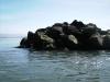
 West Sister Island
Links to related images: Nearby. Proofs. Map.
Approximate location: 37.9655157930425N / 122.47249603271W.
 Dave Littlejohn at the West Sister Island
Links to related images: Nearby. Proofs. Map.
Approximate location: 37.9881N / 122.44173W.
 Dave Littlejohn at Rat Rock
Links to related images: Nearby. Map.
Approximate location: 38.00368N / 122.462W.
 Launching after a lunch break at China Camp State Park
Links to related images: Nearby. Map.
Approximate location: 38.00076N / 122.46119W.
 West Marin Island
Links to related images: Nearby. Proofs. Map.
Approximate location: 37.96618N / 122.47187W.

 East Marin Island
Links to related images: Nearby. Proofs. Map.
Approximate location: 37.9653N / 122.47179W.
 Stuarts Point on Angel Island
Links to related images: Nearby. Proofs. Map.
Approximate location: 37.8621151487803N / 122.45189666748W.
All text and images Copyright © 2008 by Mike Higgins / contact