Mike's Kayak Journal, all photos taken on 2013-01-23
Click on the small image to see the full-sized one.

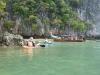
 Our support boat takes us into Pang Nga Bay, Thailand
Links to related images: Nearby. Map.
Approximate location: 8.041649N / 98.422437E.
 A Long Tailed Boat like ours in Pang Nga Bay, Thailand
Links to related images: Nearby. Map.
Approximate location: 8.039095N / 98.432715E.
 Karsk Islands visible in Pang Nga Bay, Thailand
Links to related images: Nearby. Map.
Approximate location: 8.073492N / 98.47048E.


 Joe Petolino and Mary Ann Furda in Pang Nga Bay, Thailand
Links to related images: Nearby. Map.
Approximate location: 8.099992N / 98.573542E.
 Mary Ann Furda in Pang Nga Bay, Thailand
Links to related images: Nearby. Map.
Approximate location: 8.099992N / 98.573542E.
 Approaching a Karsk limestone island in Pang Nga Bay, Thailand
Links to related images: Nearby. Map.
Approximate location: 8.215435N / 98.592253E.
 Joe named this Tiger Stripe Cliff
Links to related images: Nearby. Map.
Approximate location: 8.215435N / 98.592253E.
 Our first landing on a beach in Pang Nga Bay, Thailand
Links to related images: Nearby. Map.
Approximate location: 8.215435N / 98.592253E.
 The limestone cliff leaned over the beach in Pang Nga Bay, Thailand
Links to related images: Nearby. Map.
Approximate location: 8.215435N / 98.592253E.
 Sally Tobin was the first to launch in Pang Nga Bay, Thailand
Links to related images: Nearby. Map.
Approximate location: 8.215435N / 98.592253E.
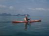
 Finally I was in a kayak in Pang Nga Bay, Thailand
Links to related images: Nearby. Map.
Approximate location: 8.215113N / 98.592188E.
 Our support boat under Tiger Stripe Cliff in Pang Nga Bay, Thailand
Links to related images: Nearby. Map.
Approximate location: 8.214104N / 98.591652E.


 Stalactites hanging off an ocean cliff in Pang Nga Bay, Thailand
Links to related images: Nearby. Map.
Approximate location: 8.218868N / 98.591394E.
 My first limestone cave in Pang Nga Bay, Thailand
Links to related images: Nearby. Map.
Approximate location: 8.219061N / 98.593283E.
 Sapling on a rock in front of a cliff in Pang Nga Bay, Thailand
Links to related images: Nearby. Map.
Approximate location: 8.214898N / 98.593605E.
 Paddling between Karsk islands in Pang Nga Bay, Thailand
Links to related images: Nearby. Map.
Approximate location: 8.201594N / 98.601565E.
 Small Karsk island in Pang Nga Bay, Thailand
Links to related images: Nearby. Map.
Approximate location: 8.194127N / 98.611114E.
 Mary-Marcia Casolhy and Joe Petolino in Pang Nga Bay, Thailand
Links to related images: Nearby. Map.
Approximate location: 8.194127N / 98.611114E.
 Small Karsk island in Pang Nga Bay, Thailand
Links to related images: Nearby. Map.
Approximate location: 8.194127N / 98.611114E.
 The intrepid kayaker paddling towards the support boat in Pang Nga Bay, Thailand
Links to related images: Nearby. Map.
Approximate location: 8.194127N / 98.611114E.
 A secret lagoon that we walked into at low tide in Pang Nga Bay, Thailand
Links to related images: Nearby. Map.
Approximate location: 8.194385N / 98.610942E.


 Inside the secret lagoon in Pang Nga Bay, Thailand
Links to related images: Nearby. Map.
Approximate location: 8.193805N / 98.612337E.

 A bumble bee in Pang Nga Bay, Thailand
Links to related images: Nearby. Map.
Approximate location: 8.194513N / 98.610556E.
 Small Karsk island in Pang Nga Bay, Thailand
Links to related images: Nearby. Map.
Approximate location: 8.194149N / 98.610921E.
 Jungle covered Karsk island in Pang Nga Bay, Thailand
Links to related images: Nearby. Map.
Approximate location: 8.193827N / 98.610921E.
 The sky was overcast, keeping us cool on Pang Nga Bay, Thailand
Links to related images: Nearby. Map.
Approximate location: 8.193591N / 98.611071E.

 Jungle covered Karsk island in Pang Nga Bay, Thailand
Links to related images: Nearby. Map.
Approximate location: 8.19241N / 98.611629E.
 Skylight in a cave on Pang Nga Bay, Thailand
Links to related images: Nearby. Map.
Approximate location: 8.192046N / 98.61135E.
 Inside a cave on Pang Nga Bay, Thailand
Links to related images: Nearby. Map.
Approximate location: 8.191981N / 98.611414E.
 Mary Ann Furda inside a cave on Pang Nga Bay, Thailand
Links to related images: Nearby. Map.
Approximate location: 8.191981N / 98.611414E.
 Karsk islands on Pang Nga Bay, Thailand
Links to related images: Nearby. Map.
Approximate location: 8.191874N / 98.61135E.
 Inside a cave on Pang Nga Bay, Thailand
Links to related images: Nearby. Map.
Approximate location: 8.191381N / 98.611543E.
 The intrepid kayaker paddling between Karsk islands in Pang Nga Bay, Thailand
Links to related images: Nearby. Map.
Approximate location: 8.192089N / 98.616092E.
 An arch, or a crack between shore rocks on Pang Nga Bay, Thailand
Links to related images: Nearby. Map.
Approximate location: 8.197517N / 98.631907E.

 The limestone hangs out over the water on Pang Nga Bay, Thailand
Links to related images: Nearby. Map.
Approximate location: 8.198977N / 98.639138E.
 Jungle covered Karsk island in Pang Nga Bay, Thailand
Links to related images: Nearby. Map.
Approximate location: 8.197925N / 98.638494E.
 Beautiful (if trashy) little beach in Pang Nga Bay, Thailand
Links to related images: Nearby. Map.
Approximate location: 8.196015N / 98.638558E.
 Vertical limestone cliffs in Pang Nga Bay, Thailand
Links to related images: Nearby. Map.
Approximate location: 8.194857N / 98.639867E.
 Small, tall, steep Karsk in Pang Nga Bay, Thailand
Links to related images: Nearby. Map.
Approximate location: 8.190608N / 98.638215E.
 We will meet the support boat at this beach in Pang Nga Bay, Thailand
Links to related images: Nearby. Map.
Approximate location: 8.190608N / 98.638215E.
All text and images Copyright © 2013 by Mike Higgins / contact