Mike's Kayak Journal, all photos taken on 2013-01-24
Click on the small image to see the full-sized one.

 Sunrise from our bungalows on Pang Nga Bay, Thailand
Links to related images: Nearby. Map.
Approximate location: 8.110807N / 98.62283E.
 Small Karsk island in Pang Nga Bay, Thailand
Links to related images: Nearby. Map.
Approximate location: 8.187561N / 98.685615E.


 Karsk islands on Pang Nga Bay, Thailand
Links to related images: Nearby. Map.
Approximate location: 8.228073N / 98.719518E.
 Our support boat takes us into Pang Nga Bay, Thailand
Links to related images: Nearby. Map.
Approximate location: 8.230069N / 98.722415E.
 Our guide Bow sits on the bow of the support boat.
Links to related images: Nearby. Map.
Approximate location: 8.257728N / 98.727458E.
 Sharon Fleming, Big and the intrepid kayaker in the support boat on Pang Nga Bay, Thailand
Links to related images: Nearby. Map.
Approximate location: 8.27631N / 98.724411E.
 The support boat approaching a karsk in Pang Nga Bay, Thailand
Links to related images: Nearby. Map.
Approximate location: 8.27631N / 98.724411E.


 We enter the kayaks from the support boat in Pang Nga Bay, Thailand
Links to related images: Nearby. Map.
Approximate location: 8.278756N / 98.726835E.
 Mangrove trees in Pang Nga Bay, Thailand
Links to related images: Nearby. Map.
Approximate location: 8.278434N / 98.726363E.
 Joe Petolino and Mary Ann Furda in Pang Nga Bay, Thailand
Links to related images: Nearby. Map.
Approximate location: 8.278799N / 98.725784E.
 Mangrove saplings in Pang Nga Bay, Thailand
Links to related images: Nearby. Map.
Approximate location: 8.279014N / 98.725312E.
 Limestone cave in Pang Nga Bay, Thailand
Links to related images: Nearby. Map.
Approximate location: 8.27955N / 98.724303E.
 A gap leading to a lagoon in Pang Nga Bay, Thailand
Links to related images: Nearby. Map.
Approximate location: 8.279572N / 98.723702E.

 Stalactites hanging off an ocean cliff in Pang Nga Bay, Thailand
Links to related images: Nearby. Map.
Approximate location: 8.279765N / 98.724046E.
 Light reflecting into a cave in Pang Nga Bay, Thailand
Links to related images: Nearby. Map.
Approximate location: 8.284872N / 98.728316E.
 Lush vegetation and limestone in Pang Nga Bay, Thailand
Links to related images: Nearby. Map.
Approximate location: 8.284872N / 98.728316E.
 Limestone rock in a lagoon in Pang Nga Bay, Thailand
Links to related images: Nearby. Map.
Approximate location: 8.285644N / 98.728166E.
 Mangroves and calm water in a lagoon in Pang Nga Bay, Thailand
Links to related images: Nearby. Map.
Approximate location: 8.286631N / 98.728445E.

 Mangroves and Mary Ann Furda in a lagoon in Pang Nga Bay, Thailand
Links to related images: Nearby. Map.
Approximate location: 8.285923N / 98.721471E.
 Sharon Fleming became a fan of kayak caving in Pang Nga Bay, Thailand
Links to related images: Nearby. Map.
Approximate location: 8.280301N / 98.723316E.


 A different species of Mangrove in Pang Nga Bay, Thailand
Links to related images: Nearby. Map.
Approximate location: 8.294613N / 98.724475E.

 Ladders used to collect bird nests for soup in Pang Nga Bay, Thailand
Links to related images: Nearby. Map.
Approximate location: 8.294206N / 98.724217E.
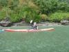 The intrepid kayaker paddling in the rain on Pang Nga Bay, Thailand
Links to related images: Nearby. Map.
Approximate location: 8.270688N / 98.724089E.
 Karsk islands on Pang Nga Bay, Thailand
Links to related images: Nearby. Map.
Approximate location: 8.235369N / 98.722222E.
 Cave clear through an island on Pang Nga Bay, Thailand
Links to related images: Nearby. Map.
Approximate location: 8.205671N / 98.703961E.
All text and images Copyright © 2013 by Mike Higgins / contact