The following images were all taken near the same location, ~30.3295993804932/115.899002075195:
Click on the small images to see the full-sized ones.
 Crossing from the mouth of Bahia San Quintin down to the open shore
Taken on 2011-08-16 .
Links to related images: Date. Proofs. Map. Story.

 The shore had lots of sandstone caves, but there were too shallow to paddle into
Taken on 2011-08-16 .
Links to related images: Date. Proofs. Map. Story.
 Bird covered island with small arch in it
Taken on 2011-08-16 .
Links to related images: Date. Proofs. Map. Story.
 Fish camp Viejo? A slot in the clif with a small beach
Taken on 2011-08-16 .
Links to related images: Date. Proofs. Map. Story.
 Another cave I could not go into
Taken on 2011-08-16 .
Links to related images: Date. Proofs. Map. Story.


 An interesting resort with people tide pooling at the shore
Taken on 2011-08-16 .
Links to related images: Date. Proofs. Map. Story.
 The resort has running water flowing into the sea
Taken on 2011-08-16 .
Links to related images: Date. Proofs. Map. Story.
 Next to the resort an optical illusion on the cliff caught my eye
Taken on 2011-08-16 .
Links to related images: Date. Proofs. Map. Story.


 That is no illusion! It is cave with a giant sinkhole in the roof!
Taken on 2011-08-16 .
Links to related images: Date. Proofs. Map. Story.

 That is no illusion! It is cave with a giant sinkhole in the roof!
Taken on 2011-08-16 .
Links to related images: Date. Proofs. Map. Story.


 The entrance to the cave was large enough that I was not worried about the southern swell
Taken on 2011-08-16 .
Links to related images: Date. Proofs. Map. Story.


 The sandstone cliffs were interesting to travel past
Taken on 2011-08-16 .
Links to related images: Date. Proofs. Map. Story.
 I passed some shorefront houses on the coast
Taken on 2011-08-16 .
Links to related images: Date. Proofs. Map. Story.
 I think this is the big beach just north of El Rosario
Taken on 2011-08-16 .
Links to related images: Date. Proofs. Map. Story.


 After a long day of paddling, I finally rounded Punta Baja
Taken on 2011-08-16 .
Links to related images: Date. Proofs. Map. Story.
 There seems to be a big town at Punta Baja that I do not recall from 10 years ago
Taken on 2011-08-16 .
Links to related images: Date. Proofs. Map. Story.

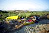
 I landed at the same arroyo I camped in 10 years ago
Taken on 2011-08-16 .
Links to related images: Date. Proofs. Map. Story.


 This time I camped in the arroyo instead of up on the bluff
Taken on 2011-08-16 .
Links to related images: Date. Proofs. Map. Story.
 Kids watching me launch at the Old Mill
Taken on 2011-08-15 .
Links to related images: Date. Proofs. Map. Story.

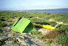
 Fishcamp out on the spit in Bahia San Quintin
Taken on 2011-08-15 .
Links to related images: Date. Proofs. Map. Story.
 Interesting rocks just flush with the sand
Taken on 2011-08-15 .
Links to related images: Date. Proofs. Map. Story.


 Rocks rounded smooth at the end of the point
Taken on 2011-08-15 .
Links to related images: Date. Proofs. Map. Story.
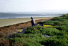
 Sandy beach at the mouth of Bahia San Quintin
Taken on 2011-08-15 .
Links to related images: Date. Proofs. Map. Story.
 Konstantin disapearing behind a 9' swell
Taken on 2001-04-9 .
Links to related images: Date. Proofs. Map. Story.
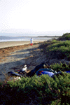 Our first morning in Baja
Taken on 2001-04-8 .
Links to related images: Date. Proofs. Map. Story.
 Konstantin on our first morning in Baja
Taken on 2001-04-8 .
Links to related images: Date. Proofs. Map. Story.
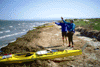 The classic 'which way to go' photo of Sid Taylor and Konstantin
Taken on 2001-04-8 .
Links to related images: Date. Proofs. Map. Story.
All text and images Copyright © 2001 by Mike Higgins / contact