The following images were all taken near the same location, ~37.6703033447266/122.501419067383:
Click on the small images to see the full-sized ones.
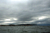
 I paddled a short section
of coastline north of the Pacifica State Beach (often
I paddled a short section
of coastline north of the Pacifica State Beach (often
Taken on 1998-10-7 .
Links to related images: Date. Proofs. Map. Story.
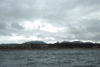
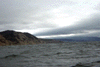 Cliffs S/ocean B
Taken on 1997-10-1 .
Links to related images: Date. Map. Story.
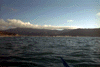
 ocean beach
Taken on 1997-10-1 .
Links to related images: Date. Map. Story.
 Ocean Beach
Taken on 1997-10-1 .
Links to related images: Date. Proofs. Map. Story.
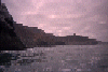
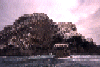 San Pedro Island viewed from the south, far away and up close.
Taken on 1996-10-10 .
Links to related images: Date. Proofs. Map. Story.
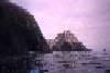
 The island is made of rock layers tilted over 60 degrees.
Taken on 1996-10-10 .
Links to related images: Date. Proofs. Map. Story.
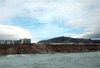
 The island is separated from the mainland by a string of rocks.
Taken on 1996-10-10 .
Links to related images: Date. Proofs. Map. Story.
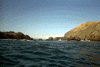
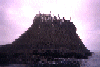
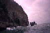
 Approaching the island from the south.
Taken on 1996-10-10 .
Links to related images: Date. Proofs. Map. Story.
 San Pedro Island viewed from the south, far away and up close.
Taken on ~1994 .
Links to related images: Date. Proofs. Map.

 The island is made of rock layers tilted over 60 degrees.
Taken on ~1994 .
Links to related images: Date. Proofs. Map.
 Approaching the island from the south.
Taken on ~1994 .
Links to related images: Date. Proofs. Map.
All text and images Copyright © by Mike Higgins / contact