Russian Gulch is the last beach for 8 miles or so, and the missing 8 miles is sometimes called the Lost Coast of Sonoma County. The name comes from a stretch of Mendocino County that is supposed to be very beautiful, also has no access, so they call it the Lost Coast. I think there is a lot more of it in Mendocino. I traveled halfway up this stretch of coast on this trip, and then came halfway down from the next beach on a later trip.
Russian Gulch is a nice beach: The road goes inland a ways, and the state parks department has a gravel parking lot and a toilet near the road. To get to the beach, you have to walk through a hundred yards or so of brush and trees that enclose you entirely in a green tunnel. Then you have to walk another hundred yards down the gravel bed of a dried up creek, and finally you have to go over the sand dune to get to the water. There are picnic tables on the south side of the dune. Once there, the waves are mild, the shore north and south is rocky and interesting, and it is the only access to the south end of the lost coast. I felt kind of stupid nosing my kayak thought the tunnel of trees, carrying it down the creek bed, and sliding it over the dune. Do real kayakers work this hard to get to the water? The last time I traveled north to here from Goat Rock, however, there were 4 people here with kayaks getting in the water! Two were in one man sit-on-top kayaks longer and slimmer than mine. They had scuba gear strapped on the back and started out into the water before I could get to shore and say hi. They paddled right past me without saying anything and went north into the lost coast. The other two guys were still getting into their wetsuits before getting into a two-man sit-on-top kayak that looked like it was manufactured by the same company that made mine. After getting snubbed by the first two guys, I felt a little shy about charging up the beach and butting into the other two guys conversation, so after a few minutes to eat my Power Bar (registered trademark) breakfast, I turned around and went back to Goat Rock. But at least now I don't feel so stupid bringing my kayaks there any more. Perhaps these guys even saw me doing it from the road, and decided that it was a good idea!
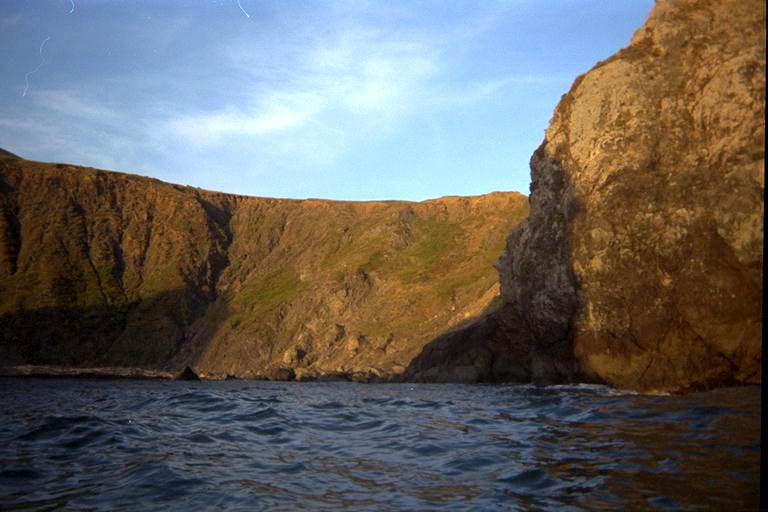
I had high hopes for the Lost Coast. I thought that there would be great big sandy beaches with no other people and places high enough out of the tides to camp. I figured to scout them out with the kayak, and then take Marty back here in the kevlar canoe to camp out. But after the first mile, which is very rocky and interesting with no sandy beaches, the rest of the lost coast is rather boring. The bluff slopes down into the ocean, and there is a field of boulders at the bottom of the bluff. At least the time that I was out there, the waves were large and broke before getting to the boulders, so I had to stay away from the shore for most of the trip. The water appears to be shallow along this stretch, with a lot of kelp growing near the shore.
I tried going close to the boulders once and went in-between two rocks that were reasonably far part but only a few feet out of the water. A big wave came and broke over the first one. I was too close to the seaward rock to turn into the wave, so it picked up the kayak and threw me off. I came right back up next to the kayak with my feet tangled up in kelp. This was the first time I had needed all my safety equipment, and I actually had not practiced getting into the kayak from the water, especially not with my feet tied together. I managed to pull my feet loose and heave myself into the kayak just in time to get rolled out again by the next wave. It occured to me that I was miles from the nearest beach and probably invisible from Hwy 1 way overhead. I started worrying about getting smashed into the land-ward rock, so I rushed back into the kayak and paddled like crazy to get out from between these two. I wasn't breathing heavy, but I had a shiver that should have been taken care of by my wetsuit. I stayed well away from rocks for the rest of this trip.
I didn't find the lost sandy beaches I had hoped for, but in the rocky area south of the boring part there were a few places that a larger canoe could land. One rock in particular, had a pebbly beach on the north side of it. From the tops of the 5 foot swells, I could see the waves breaking on this beach, and they were little tiny waves, only inches tall. I paddled closer and closer around the rock trying to figure out where the big waves were going. I turned around and backed in, the better to see my fate coming and try to get back out to sea to avoid it. I stayed close to the rock where the water felt deeper and therefore safer. I saw a large wave coming! YAAAAH! Six feet tall! But the wave shrank down and down as it approached me until it turned into this little one foot swell under me, and didn't break until it hit the beach. I told Marty about this, and she is enthusiastic about going there for a picnic lunch one day in the kevlar canoe. I'll report how it goes in the pages of this log when we get around to it.