Keller Beach to Red Rock, October 14th 1995.
Click on the small image to see the full-sized one.
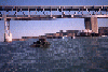
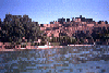
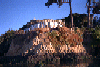
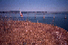
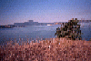
 Castro Rocks in front of the Richmond Bridge
Links to related images: Nearby. Proofs. Map.
Approximate location: 37.9326057434082N / 122.41764831543W.
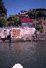
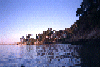
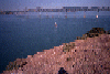
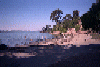 Keller Beach on a sunny day on the bay
Links to related images: Nearby. Proofs. Map.
Approximate location: 37.9208145141602N / 122.386657714844W.
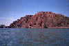
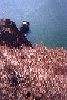
 Keller Beach viewed from offshore
Links to related images: Nearby. Proofs. Map.
Approximate location: 37.9206390380859N / 122.387145996094W.
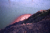
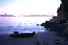 Kayak on Keller Beach late in the evening
Links to related images: Nearby. Proofs. Map.
Approximate location: 37.9331016540527N / 122.404998779297W.
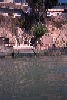 Old personal boat ramp on Point Richmond
Links to related images: Nearby. Proofs. Map.
Approximate location: 37.9224090576172N / 122.388832092285W.
 Flowering bushes on Point Richmond
Links to related images: Nearby. Proofs. Map.
Approximate location: 37.9226379394531N / 122.389801025391W.
 Incredible deck over water at Point Richmond
Links to related images: Nearby. Proofs. Map.
Approximate location: 37.9224662780762N / 122.390670776367W.
 Boathouse with red flowers on roof at Point Richmond
Links to related images: Nearby. Proofs. Map.
Approximate location: 37.9252243041992N / 122.39128112793W.

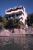
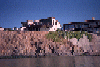 Modern house above bluff at Point Richmond
Links to related images: Nearby. Proofs. Map.
Approximate location: 37.9270439147949N / 122.393768310547W.

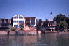 Nice houses above water at Point Richmond
Links to related images: Nearby. Proofs. Map.
Approximate location: 37.9270439147949N / 122.393768310547W.
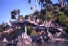
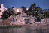 Stone terraces down to water at Point Richmond
Links to related images: Nearby. Proofs. Map.
Approximate location: 37.9270439147949N / 122.393768310547W.
 Modern house above the water at Point Richmond
Links to related images: Nearby. Proofs. Map.
Approximate location: 37.9280281066895N / 122.39476776123W.
 Nice houses above water at Point Richmond
Links to related images: Nearby. Proofs. Map.
Approximate location: 37.9286270141602N / 122.395874023438W.
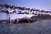
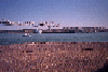
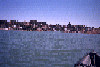 Point Richmond houses from farther ofshore
Links to related images: Nearby. Proofs. Map.
Approximate location: 37.9240226745605N / 122.396408081055W.
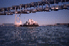
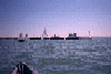 Sail boats going around supertanker
Links to related images: Nearby. Proofs. Map.
Approximate location: 37.921314239502N / 122.417053222656W.
 Sailboat between me and Red Rock Island
Links to related images: Nearby. Proofs. Map.
Approximate location: 37.9233474731445N / 122.419456481934W.
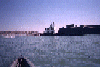 Tugboat pushing supertanker sideways
Links to related images: Nearby. Proofs. Map.
Approximate location: 37.9205017089844N / 122.412071228027W.
 Tugboat pushing barge quickly past me
Links to related images: Nearby. Proofs. Map.
Approximate location: 37.9219245910645N / 122.422798156738W.
 Funky beach houses at Point Richmond
Links to related images: Nearby. Proofs. Map.
Approximate location: 37.9294052124023N / 122.397605895996W.
 Desiner house above rocky Point Richmond shoreline
Links to related images: Nearby. Proofs. Map.
Approximate location: 37.928882598877N / 122.39623260498W.
 Evening light on Point Richmond shorefront houses
Links to related images: Nearby. Proofs. Map.
Approximate location: 37.9222640991211N / 122.389389038086W.
 Approaching Red Rock Island
Links to related images: Nearby. Proofs. Map.
Approximate location: 37.9281120300293N / 122.428886413574W.
 The view from the beach on Red Rock Island
Links to related images: Nearby. Proofs. Map.
Approximate location: 37.9300842285156N / 122.430786132812W.
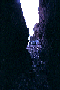
 The view from inside the cave on the east side of Red Rock Island
Links to related images: Nearby. Proofs. Map.
Approximate location: 37.9293632507324N / 122.431930541992W.
 The San Rafael Bridge viewed from the flag at the top of Red Rock Island
Links to related images: Nearby. Proofs. Map.
Approximate location: 37.9292373657227N / 122.43098449707W.
 Sailboat under the San Rafael Bridge from the top of Red Rock Island
Links to related images: Nearby. Proofs. Map.
Approximate location: 37.9292373657227N / 122.43098449707W.
 The south end of Red Rock Island viewed from the top
Links to related images: Nearby. Proofs. Map.
Approximate location: 37.9292373657227N / 122.43098449707W.
 The beach on the north end of Red Rock Island viewed from the top
Links to related images: Nearby. Proofs. Map.
Approximate location: 37.9292373657227N / 122.43098449707W.
 Yerba Buena, San Francisco, Angel Island and Tiburon from the top of Red Rock Is
Links to related images: Nearby. Proofs. Map.
Approximate location: 37.9292373657227N / 122.43098449707W.
 Mount Tam viewed from the top of Red Rock Island
Links to related images: Nearby. Proofs. Map.
Approximate location: 37.9292373657227N / 122.43098449707W.
 Richmond viewed from the top of Red Rock Island
Links to related images: Nearby. Proofs. Map.
Approximate location: 37.9292373657227N / 122.43098449707W.
 The east side of Red Rock Island viewed from the top
Links to related images: Nearby. Proofs. Map.
Approximate location: 37.9292373657227N / 122.43098449707W.
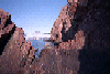 Richmond Bridge viewed through rocks on the shore of Red Rock Island
Links to related images: Nearby. Proofs. Map.
Approximate location: 37.9281196594238N / 122.43025970459W.
 Looking through the small arch on the north end of Red Rock Island
Links to related images: Nearby. Proofs. Map.
Approximate location: 37.9298057556152N / 122.432037353516W.
 The junk piled on the north end of Red Rock Island
Links to related images: Nearby. Proofs. Map.
Approximate location: 37.9300308227539N / 122.430763244629W.
All text and images Copyright © 1995 by Mike Higgins / contact