Humboldt County, Cape Mendocino to Miller Flat, August 15th, 2000.
Click on the small image to see the full-sized one.
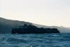
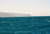
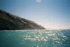
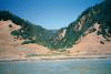
 Passing Steamboat Rock the next morning.
Links to related images: Nearby. Proofs. Map.
Approximate location: 40.4027442932129N / 124.394546508789W.
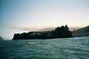
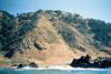
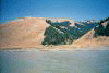
 The view back to Mendocino Point and ahead to Punta Gorda.
Links to related images: Nearby. Proofs. Map.
Approximate location: 40.3710060119629N / 124.378799438477W.


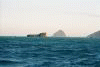
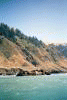
 Rounding Punta Gorda. (Do you see the hikers on the Lost Coast Trail?)
Links to related images: Nearby. Proofs. Map.
Approximate location: 40.2549018859863N / 124.364723205566W.

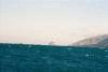
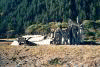
 The Punta Gorda Lighthouse is low and close to the water.
Links to related images: Nearby. Proofs. Map.
Approximate location: 40.2480621337891N / 124.351852416992W.
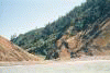
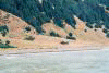
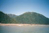
 Norther Lost Coast shoreline.
Links to related images: Nearby. Proofs. Map.
Approximate location: 40.2116546630859N / 124.309013366699W.
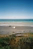

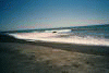
 I land at Spanish Flat but don't like the exposed beach for camping.
Links to related images: Nearby. Proofs. Map.
Approximate location: 40.1810035705566N / 124.248748779297W.

 I continue down the coast looking for a protected place.
Links to related images: Nearby. Proofs. Map.
Approximate location: 40.1395149230957N / 124.195976257324W.
 And land at Miller Flat after a long day.
Links to related images: Nearby. Proofs. Map.
Approximate location: 40.1290168762207N / 124.179840087891W.
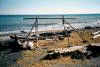
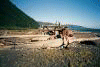
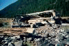 Miller Flat has many driftwood structures to camp in out of the wind.
Links to related images: Nearby. Proofs. Map.
Approximate location: 40.129280090332N / 124.179473876953W.
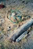 Other campers direct me to the miracle of (sun warmed) running water for a shower
Links to related images: Nearby. Proofs. Map.
Approximate location: 40.1307792663574N / 124.182899475098W.
 One of which I move into for the night.
Links to related images: Nearby. Proofs. Map.
Approximate location: 40.1290588378906N / 124.179290771484W.
 Miller Flat has many driftwood structures to camp in out of the wind.
Links to related images: Nearby. Proofs. Map.
Approximate location: 40.1289253234863N / 124.178726196289W.
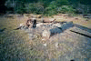
 The intrepid kayaker camping in a driftwood shelter
Links to related images: Nearby. Proofs. Map.
Approximate location: 40.128532409668N / 124.177993774414W.
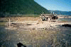
 Miller Flat has many driftwood structures to camp in out of the wind.
Links to related images: Nearby. Proofs. Map.
Approximate location: 40.1283416748047N / 124.177520751953W.
All text and images Copyright © 2000 by Mike Higgins / contact