Mike's Kayak Journal, all photos taken on 2000-10-11
Click on the small image to see the full-sized one.
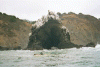
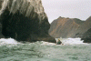
 The Cluster Cone Rocks on the Lost Coast
Links to related images: Nearby. Proofs. Map.
Approximate location: 39.9168014526367N / 123.947998046875W.
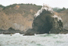
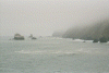 Looking north towards Morgan Rock on the Lost Coast
Links to related images: Nearby. Proofs. Map.
Approximate location: 39.9168014526367N / 123.947998046875W.
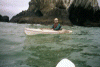
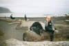 John Somers getting ready to launch at Bear Harbor
Links to related images: Nearby. Proofs. Map.
Approximate location: 39.9168014526367N / 123.947998046875W.
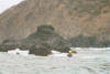
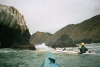
 The Cluster Cone Rocks viewed from the water
Links to related images: Nearby. Proofs. Map.
Approximate location: 39.9168014526367N / 123.947998046875W.
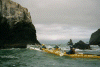
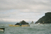
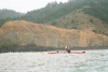 BASKers paddling north out of Bear Harbor
Links to related images: Nearby. Proofs. Map.
Approximate location: 39.9168014526367N / 123.947998046875W.
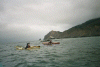 BASKers paddling north to Morgan Rock on the Lost Coast
Links to related images: Nearby. Proofs. Map.
Approximate location: 39.9168014526367N / 123.947998046875W.
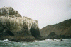
 Morgan Rock on the Lost Coast
Links to related images: Nearby. Proofs. Map.
Approximate location: 39.9168014526367N / 123.947998046875W.
 Me lining up at the back entrance to Morgan Rock
Links to related images: Nearby. Proofs. Map.
Approximate location: 39.9168014526367N / 123.947998046875W.
 Me behind Morgan Rock
Links to related images: Nearby. Proofs. Map.
Approximate location: 39.9168014526367N / 123.947998046875W.
 The intrepid kayaker entering the back of the Morgan Rock Cave
Links to related images: Nearby. Proofs. Map.
Approximate location: 39.9168014526367N / 123.947998046875W.
 Me behind Morgan Rock
Links to related images: Nearby. Proofs. Map.
Approximate location: 39.9168014526367N / 123.947998046875W.
 Lucy O'brien, John Somers and I behind Morgan Rock
Links to related images: Nearby. Proofs. Map.
Approximate location: 39.9168014526367N / 123.947998046875W.
 Lucy O'brien starting into the cave through Morgan Rock
Links to related images: Nearby. Proofs. Map.
Approximate location: 39.9168014526367N / 123.947998046875W.
 Fred Cooper at Morgan Rock
Links to related images: Nearby. Proofs. Map.
Approximate location: 39.9168014526367N / 123.947998046875W.
 Kayakers, including me, at the back of Morgan Rock
Links to related images: Nearby. Proofs. Map.
Approximate location: 39.9168014526367N / 123.947998046875W.
 John Somers and I leaving Morgan Rock
Links to related images: Nearby. Proofs. Map.
Approximate location: 39.9168014526367N / 123.947998046875W.
 Cluster Cone Rocks in front of Bear Harbor
Links to related images: Nearby. Proofs. Map.
Approximate location: 39.9168014526367N / 123.947998046875W.
All text and images Copyright © 2000 by Mike Higgins / contact