The following images were all taken near the same location, ~39.9168014526367/123.947998046875:
Click on the small images to see the full-sized ones.
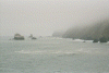
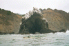
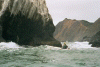
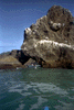
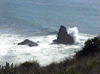
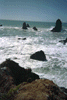
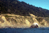
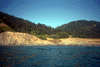
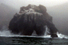
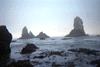
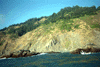
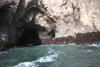
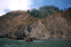
 The Cluster Cone Rocks on the Lost Coast
Taken on 2000-10-11 .
Links to related images: Date. Proofs. Map.
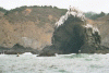
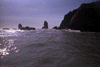
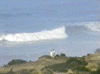
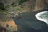
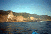
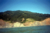
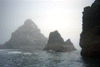
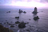
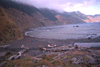
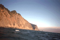
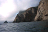
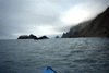
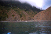
 Looking north towards Morgan Rock on the Lost Coast
Taken on 2000-10-11 .
Links to related images: Date. Proofs. Map.
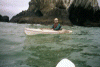
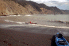
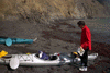
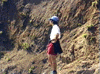
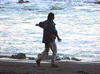
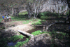
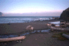
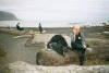 John Somers getting ready to launch at Bear Harbor
Taken on 2000-10-11 .
Links to related images: Date. Proofs. Map.
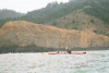
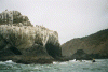
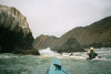
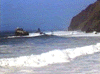
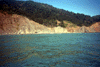
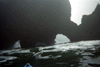
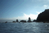
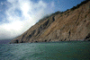
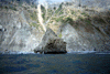
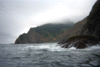
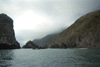
 The Cluster Cone Rocks viewed from the water
Taken on 2000-10-11 .
Links to related images: Date. Proofs. Map.
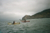
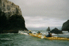
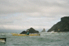
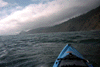
 BASKers paddling north out of Bear Harbor
Taken on 2000-10-11 .
Links to related images: Date. Proofs. Map.
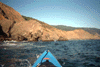
 BASKers paddling north to Morgan Rock on the Lost Coast
Taken on 2000-10-11 .
Links to related images: Date. Proofs. Map.
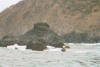
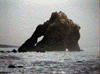
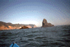
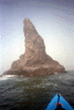
 Morgan Rock on the Lost Coast
Taken on 2000-10-11 .
Links to related images: Date. Proofs. Map.
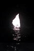
 Me lining up at the back entrance to Morgan Rock
Taken on 2000-10-11 .
Links to related images: Date. Proofs. Map.
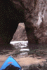
 Me behind Morgan Rock
Taken on 2000-10-11 .
Links to related images: Date. Proofs. Map.
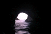
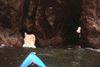
 The intrepid kayaker entering the back of the Morgan Rock Cave
Taken on 2000-10-11 .
Links to related images: Date. Proofs. Map.
 Me behind Morgan Rock
Taken on 2000-10-11 .
Links to related images: Date. Proofs. Map.
 Lucy O'brien, John Somers and I behind Morgan Rock
Taken on 2000-10-11 .
Links to related images: Date. Proofs. Map.
 Lucy O'brien starting into the cave through Morgan Rock
Taken on 2000-10-11 .
Links to related images: Date. Proofs. Map.
 Fred Cooper at Morgan Rock
Taken on 2000-10-11 .
Links to related images: Date. Proofs. Map.
 Kayakers, including me, at the back of Morgan Rock
Taken on 2000-10-11 .
Links to related images: Date. Proofs. Map.
 John Somers and I leaving Morgan Rock
Taken on 2000-10-11 .
Links to related images: Date. Proofs. Map.
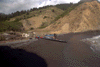
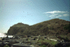
 Cluster Cone Rocks in front of Bear Harbor
Taken on 2000-10-11 .
Links to related images: Date. Proofs. Map.

 Approaching the end of our afternoon paddle.
Taken on 1998-10-12 .
Links to related images: Date. Proofs. Map. Story.
 Landing in the protected waters at Bear Harbor requires landing at high tide
wh
Landing in the protected waters at Bear Harbor requires landing at high tide
wh
Taken on 1998-10-12 .
Links to related images: Date. Proofs. Map. Story.
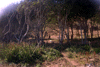
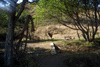

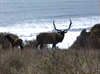
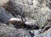
 Elk in my favorite campground at Bear Harbor
Taken on 1998-10-12 .
Links to related images: Date. Proofs. Map. Story.
 Landing in the protected waters at Bear Harbor requires landing at high tide
wh
Landing in the protected waters at Bear Harbor requires landing at high tide
wh
Taken on 1998-10-12 .
Links to related images: Date. Proofs. Map. Story.
 Charles and Brian were two of the kayakers who drove in to meet us.
Taken on 1998-10-12 .
Links to related images: Date. Proofs. Map. Story.

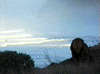
 When we arrived we found my favorite campsite was claimed by a large
bull elk a
When we arrived we found my favorite campsite was claimed by a large
bull elk a
Taken on 1998-10-12 .
Links to related images: Date. Proofs. Map. Story.
 Charles and Brian were two of the kayakers who drove in to meet us.
Taken on 1998-10-12 .
Links to related images: Date. Proofs. Map. Story.
 Roger Lamb and I played around the Cluster Cone Rocks and through Morgan Rock (
Taken on 1998-10-12 .
Links to related images: Date. Proofs. Map. Story.
 On Saturday we paddled north past the Needle Rock Visitors Center but
made our
On Saturday we paddled north past the Needle Rock Visitors Center but
made our
Taken on 1998-10-12 .
Links to related images: Date. Proofs. Map. Story.
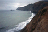
 On Sunday we paddled south to the Anderson Cliffs (in the distance)
and landed
On Sunday we paddled south to the Anderson Cliffs (in the distance)
and landed
Taken on 1998-10-12 .
Links to related images: Date. Proofs. Map. Story.
 Roger Lamb and I played around the Cluster Cone Rocks and through Morgan Rock (
Taken on 1998-10-12 .
Links to related images: Date. Proofs. Map. Story.
 If you land at low tide the water exposes rocks to bang up kayaks.
Taken on 1998-10-12 .
Links to related images: Date. Proofs. Map. Story.
 Roger Lamb and I played around the Cluster Cone Rocks and through Morgan Rock (
Taken on 1998-10-12 .
Links to related images: Date. Proofs. Map. Story.
 On Sunday we paddled south to the Anderson Cliffs (in the distance)
and landed
On Sunday we paddled south to the Anderson Cliffs (in the distance)
and landed
Taken on 1998-10-12 .
Links to related images: Date. Proofs. Map. Story.
 The waves were calm enough to land near Anderson Cliffs
Taken on 1998-10-12 .
Links to related images: Date. Proofs. Map. Story.
 On the trip home Sunday afternoon I went through every cave and arch!
Taken on 1998-10-12 .
Links to related images: Date. Proofs. Map. Story.
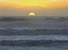
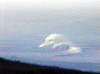
 12 foot swell from the Gulf of Alaska broke far from shore.
Taken on 1997-10-5 .
Links to related images: Date. Proofs. Map. Story.
 I found a message in a bottle!
Taken on 1997-10-5 .
Links to related images: Date. Proofs. Map. Story.
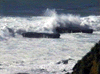
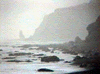
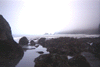
 Even protected Bear Harbor was rough with even rougher waves offshore.
Taken on 1997-10-5 .
Links to related images: Date. Proofs. Map. Story.
 Sami Iwata was the only BASKer who came came despite the weather.
Taken on 1997-10-5 .
Links to related images: Date. Proofs. Map. Story.
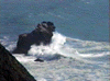
 Morgan Rock had waves breaking around it and blasting through the arch.
Taken on 1997-10-5 .
Links to related images: Date. Proofs. Map. Story.

 The Cluster Cone rocks looked impossible to navigate through.
Taken on 1997-10-5 .
Links to related images: Date. Proofs. Map. Story.
 Morgan Rock had waves breaking around it and blasting through the arch.
Taken on 1997-10-5 .
Links to related images: Date. Proofs. Map. Story.
 North Rock also has waves breaking around it.
Taken on 1997-10-5 .
Links to related images: Date. Proofs. Map. Story.
 Morgan Rock had waves breaking around it and blasting through the arch.
Taken on 1997-10-5 .
Links to related images: Date. Proofs. Map. Story.
 Last trip here, I paddled between the last two flat rocks offshore from
Flat Ro
Last trip here, I paddled between the last two flat rocks offshore from
Flat Ro
Taken on 1997-10-5 .
Links to related images: Date. Proofs. Map. Story.
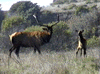
 Everywhere we went we saw huge Roosevelt's elk, including these large intimidat
Taken on 1997-10-5 .
Links to related images: Date. Proofs. Map. Story.
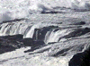
 Several creeks flowed into the beach and disapeared into the sand. As the
water
Several creeks flowed into the beach and disapeared into the sand. As the
water
Taken on 1997-10-5 .
Links to related images: Date. Proofs. Map. Story.

 We went for a walk from one campground to another at low tide around sunset.
Taken on 1997-10-5 .
Links to related images: Date. Proofs. Map. Story.
 Sami did a little dance to try and make a pelikin fly in front of the sunset
to
Sami did a little dance to try and make a pelikin fly in front of the sunset
to
Taken on 1997-10-5 .
Links to related images: Date. Proofs. Map. Story.
 Needle Rock viewed through several of its arches.
Taken on 1997-10-5 .
Links to related images: Date. Proofs. Map. Story.
 This tall thin rock was near our destination, the access to the next campground
Taken on 1997-10-5 .
Links to related images: Date. Proofs. Map. Story.
 Everywhere we went we saw huge Roosevelt's elk, including these large intimidat
Taken on 1997-10-5 .
Links to related images: Date. Proofs. Map. Story.
 Needle Rock viewed through several of its arches.
Taken on 1997-10-5 .
Links to related images: Date. Proofs. Map. Story.
 This tall thin rock was near our destination, the access to the next campground
Taken on 1997-10-5 .
Links to related images: Date. Proofs. Map. Story.
 12 foot swell from the Gulf of Alaska broke far from shore.
Taken on 1997-10-5 .
Links to related images: Date. Proofs. Map. Story.

 Bear Camp
Taken on 1997-10-3 .
Links to related images: Date. Proofs. Map.
 Bear Harbor
Taken on 1997-10-3 .
Links to related images: Date. Proofs. Map.
 Bear Hrbr Beach
Taken on 1997-10-3 .
Links to related images: Date. Proofs. Map.
 Cluster Cone R
Taken on 1997-10-3 .
Links to related images: Date. Proofs. Map.
 N to Morgan R
Taken on 1997-10-3 .
Links to related images: Date. Proofs. Map.
 Bear harbor Pnt
Taken on 1997-10-3 .
Links to related images: Date. Proofs. Map.
 View N of Needle
Taken on 1997-10-3 .
Links to related images: Date. Proofs. Map.
 Clus.Cone Daylite
Taken on 1997-07-4 .
Links to related images: Date. Proofs. Map.
 Morgan Rock
Taken on 1997-07-4 .
Links to related images: Date. Proofs. Map.
 North Rock daylight
Taken on 1997-07-4 .
Links to related images: Date. Proofs. Map.
 arches near shore
Taken on 1997-07-4 .
Links to related images: Date. Proofs. Map.
 point south of Flat R
Taken on 1997-07-4 .
Links to related images: Date. Proofs. Map.
 flat rock point
Taken on 1997-07-4 .
Links to related images: Date. Proofs. Map.
 Needle R Visitor Cntr
Taken on 1997-07-4 .
Links to related images: Date. Proofs. Map.
 cambround beach?
Taken on 1997-07-4 .
Links to related images: Date. Proofs. Map.
 campground cliff?
Taken on 1997-07-4 .
Links to related images: Date. Proofs. Map.
 campground beach?
Taken on 1997-07-4 .
Links to related images: Date. Proofs. Map.
 cliffs
Taken on 1997-07-4 .
Links to related images: Date. Proofs. Map.
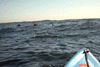 Dolphins!
Taken on 1997-07-4 .
Links to related images: Date. Proofs. Map.
 Needle Rock
Taken on 1997-07-4 .
Links to related images: Date. Proofs. Map.
 small arches
Taken on 1997-07-4 .
Links to related images: Date. Proofs. Map.
 North Rock
Taken on 1997-07-4 .
Links to related images: Date. Proofs. Map.
 Morgan Rock
Taken on 1997-07-4 .
Links to related images: Date. Proofs. Map.
 in cluster in fog
Taken on 1997-07-4 .
Links to related images: Date. Proofs. Map.
 walk to Clus Cone
Taken on 1997-07-4 .
Links to related images: Date. Proofs. Map.
 tide pool N
Taken on 1997-07-4 .
Links to related images: Date. Proofs. Map.
 low tide W beach
Taken on 1997-07-4 .
Links to related images: Date. Proofs. Map.
 low tide E beach
Taken on 1997-07-4 .
Links to related images: Date. Proofs. Map.
 View S
Taken on 1997-07-4 .
Links to related images: Date. Proofs. Map.
 N of Harbor
Taken on 1997-07-4 .
Links to related images: Date. Proofs. Map.
 Cl.Cone Above
Taken on 1997-07-4 .
Links to related images: Date. Proofs. Map.
 beach E end
Taken on 1997-07-4 .
Links to related images: Date. Proofs. Map.
 beach W end
Taken on 1997-07-4 .
Links to related images: Date. Proofs. Map.
 Cluster Cone Rocks
Taken on 1997-07-4 .
Links to related images: Date. Proofs. Map.
 arch in cliffs
Taken on 1997-07-4 .
Links to related images: Date. Proofs. Map.
 beach w/birds
Taken on 1997-07-4 .
Links to related images: Date. Proofs. Map.
 bear harbor dist
Taken on 1997-07-4 .
Links to related images: Date. Proofs. Map.
 seals on rocks
Taken on 1997-07-4 .
Links to related images: Date. Proofs. Map.
 view back
Taken on 1997-07-4 .
Links to related images: Date. Proofs. Map.
 next point
Taken on 1997-07-4 .
Links to related images: Date. Proofs. Map.
 next beach
Taken on 1997-07-4 .
Links to related images: Date. Proofs. Map.
 next point
Taken on 1997-07-4 .
Links to related images: Date. Proofs. Map.
 cave in point
Taken on 1997-07-4 .
Links to related images: Date. Proofs. Map.
 point up close
Taken on 1997-07-4 .
Links to related images: Date. Proofs. Map.
 Rocky pnt N
Taken on 1997-07-4 .
Links to related images: Date. Proofs. Map.
 R with small arches
Taken on 1997-07-4 .
Links to related images: Date. Proofs. Map.
 fog lifting
Taken on 1997-07-4 .
Links to related images: Date. Proofs. Map.
 cluster cone R?
Taken on 1997-07-4 .
Links to related images: Date. Proofs. Map.
 back out narrow A
Taken on 1997-07-4 .
Links to related images: Date. Proofs. Map.
 narrow arch
Taken on 1997-07-4 .
Links to related images: Date. Proofs. Map.
 next beach
Taken on 1997-07-4 .
Links to related images: Date. Proofs. Map.
 point up close
Taken on 1997-07-4 .
Links to related images: Date. Proofs. Map.
 first arch
Taken on 1997-07-4 .
Links to related images: Date. Proofs. Map.
 Next 2 points
Taken on 1997-07-4 .
Links to related images: Date. Proofs. Map.
 First Beach
Taken on 1997-07-4 .
Links to related images: Date. Proofs. Map.
 two caves
Taken on 1997-07-4 .
Links to related images: Date. Proofs. Map.
 waterfall
Taken on 1997-07-4 .
Links to related images: Date. Proofs. Map.
 Rock Garden
Taken on 1997-07-4 .
Links to related images: Date. Proofs. Map.
All text and images Copyright © 1997 by Mike Higgins / contact