Isla Todos Santos to El Puerto, October 11th 2007.
Click on the small image to see the full-sized one.
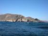
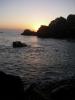 Sunrise on Isla Todos Santos
Links to related images: Nearby. Proofs. Map.
Approximate location: 31.80544N / 116.78907W.
 Charles Harris and Gregg Berman packing to leave
Links to related images: Nearby. Proofs. Map.
Approximate location: 31.80548N / 116.78864W.
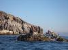
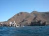
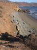
 Morning light on the rocks of Isla Todos Santos
Links to related images: Nearby. Proofs. Map.
Approximate location: 31.80555N / 116.78847W.
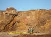
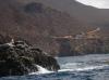
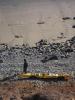
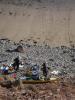
 Aquaculture workers at Isla Todos Santos
Links to related images: Nearby. Proofs. Map.
Approximate location: 31.80583N / 116.78574W.

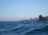
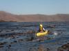
 Sea lion watching Gregg Berman off Isla Todos Santos
Links to related images: Nearby. Proofs. Map.
Approximate location: 31.79692N / 116.78589W.
 A tugboat crosses our path
Links to related images: Nearby. Proofs. Map.
Approximate location: 31.76079N / 116.76038W.
 Looking back to Isla Todos Santos behind Charles Harris
Links to related images: Nearby. Proofs. Map.
Approximate location: 31.76079N / 116.76038W.
 The light at Cabo Banda
Links to related images: Nearby. Proofs. Map.
Approximate location: 31.74055N / 116.74722W.
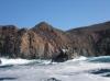
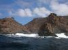
 The rough shoreline of Cabo Banda
Links to related images: Nearby. Proofs. Map.
Approximate location: 31.7333N / 116.73592W.
 Gregg Berman in front of the rough shoreline of Cabo Banda
Links to related images: Nearby. Proofs. Map.
Approximate location: 31.72448N / 116.72641W.
 The rough shoreline of Cabo Banda
Links to related images: Nearby. Proofs. Map.
Approximate location: 31.72448N / 116.72641W.


 Gregg Berman in front of La Bufadora, the famous blow-hole
Links to related images: Nearby. Proofs. Map.
Approximate location: 31.72352N / 116.72306W.
 The rough shoreline of Cabo Banda
Links to related images: Nearby. Proofs. Map.
Approximate location: 31.71474N / 116.71628W.
 The water calms down as we head south
Links to related images: Nearby. Proofs. Map.
Approximate location: 31.71086N / 116.70697W.


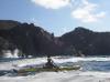
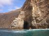 Gregg Berman in a cave
Links to related images: Nearby. Proofs. Map.
Approximate location: 31.71285N / 116.70671W.
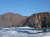
 The water calms down as we head south
Links to related images: Nearby. Proofs. Map.
Approximate location: 31.69388N / 116.67819W.

 Charles Harris in calm water
Links to related images: Nearby. Proofs. Map.
Approximate location: 31.60224N / 116.67903W.
 Old freighter anchored offshore
Links to related images: Nearby. Proofs. Map.
Approximate location: 31.60224N / 116.67903W.
 Diver down, no-one on board
Links to related images: Nearby. Proofs. Map.
Approximate location: 31.5973N / 116.68094W.
 Coastline too rough to camp here
Links to related images: Nearby. Proofs. Map.
Approximate location: 31.5552N / 116.69461W.
 Charles Harris in a kelp bed
Links to related images: Nearby. Proofs. Map.
Approximate location: 31.55072N / 116.68927W.
 Campsite on Punta Santo Tomas
Links to related images: Nearby. Proofs. Map.
Approximate location: 31.55501N / 116.67742W.
 Gregg Berman at Punta Santo Tomas
Links to related images: Nearby. Proofs. Map.
Approximate location: 31.55499N / 116.67749W.
 Charles Harris and Gregg Berman at Punta Santo Tomas
Links to related images: Nearby. Proofs. Map.
Approximate location: 31.55499N / 116.67749W.
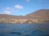
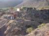 El Puerto, the town on Punta Santo Tomas
Links to related images: Nearby. Proofs. Map.
Approximate location: 31.55499N / 116.67749W.
All text and images Copyright © 2007 by Mike Higgins / contact