The following images were all taken near the same location, ~32.6406517028809/117.179481506348:
Click on the small images to see the full-sized ones.
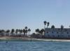
 Safely back in Imperial Beach after the expedition was over
Taken on 2007-10-19 .
Links to related images: Date. Proofs. Map.
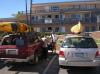
 Gregg Berman packing his kayak in Imperial Beach
Taken on 2007-10-7 .
Links to related images: Date. Proofs. Map. Story.
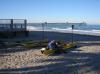
 Looking back at Imperial Beach after launching
Taken on 2007-10-7 .
Links to related images: Date. Proofs. Map. Story.
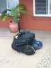
 My kayak and all my camping gear in three duffel bags
Taken on 2005-10-1 .
Links to related images: Date. Proofs. Map.
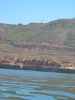
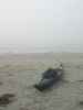
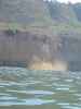 A piece of the cliff calved off and fell into the sea as I paddled by!
Taken on 2005-09-30 .
Links to related images: Date. Proofs. Map. Story.
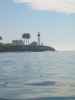
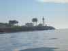
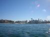
 The fog lifted long enough to see the lighthouses at the tip of Point Loma
Taken on 2005-09-30 .
Links to related images: Date. Proofs. Map. Story.
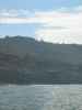
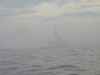
 Then the fog came back when I wanted to cross the channel
Taken on 2005-09-30 .
Links to related images: Date. Proofs. Map. Story.

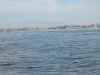
 A floating dock appeared out of the fog as I paddled south
Taken on 2005-09-30 .
Links to related images: Date. Proofs. Map. Story.
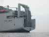
 This tugboat is from San Francisco, what's it doing in San Diego?
Taken on 2005-09-30 .
Links to related images: Date. Proofs. Map. Story.

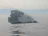
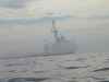
 Some kind of navy ship also apeared
Taken on 2005-09-30 .
Links to related images: Date. Proofs. Map. Story.
 I could see the motel I would stay in, but still had miles to go
Taken on 2005-09-30 .
Links to related images: Date. Proofs. Map. Story.
 The last landing of the trip at Imperial Beach
Taken on 2005-09-30 .
Links to related images: Date. Proofs. Map. Story.
All text and images Copyright © 2005 by Mike Higgins / contact