The following images were all taken near the same location, ~38.9111709594727/123.712661743164:
Click on the small images to see the full-sized ones.
 Dave Littlejohn and Dörte Mann ready to launch the next morning
Taken on 2009-05-31 .
Links to related images: Date. Proofs. Map. Story.


 Dave Littlejohn is such a gentleman, he helps Dörte Mann launch
Taken on 2009-05-31 .
Links to related images: Date. Proofs. Map. Story.
 Actually, Dave Littlejohn is not a gentleman, Dörte Manns skeg was stuck, he was only concerned with not breaking it
Taken on 2009-05-31 .
Links to related images: Date. Proofs. Map. Story.


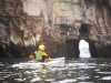
 Rock gardens near Iverson Point, a little too rough, the tide a little too low
Taken on 2009-05-31 .
Links to related images: Date. Proofs. Map. Story.

 Dörte Mann and Dave Littlejohn looking at the poachers cashe
Taken on 2009-05-31 .
Links to related images: Date. Proofs. Map. Story.

 Landed for a break near Gordons Beach
Taken on 2009-05-31 .
Links to related images: Date. Proofs. Map. Story.
 Dörte Mann does not like the fishy smell in the Pont Arena Cove parking lot
Taken on 2009-05-30 .
Links to related images: Date. Proofs. Map. Story.
 Loading the kayaks at Pont Arena Cove
Taken on 2009-05-30 .
Links to related images: Date. Proofs. Map. Story.
 Calm water in Pont Arena Cove
Taken on 2009-05-30 .
Links to related images: Date. Proofs. Map. Story.
 Dave Littlejohn and Dörte Mann in Pont Arena Cove
Taken on 2009-05-30 .
Links to related images: Date. Proofs. Map. Story.


 A cave just outside Pont Arena Cove
Taken on 2009-05-30 .
Links to related images: Date. Proofs. Map. Story.

 A row of arches framing the Point Arena Lighthouse
Taken on 2009-05-30 .
Links to related images: Date. Proofs. Map. Story.
 Narrow arch near Point Arena
Taken on 2009-05-30 .
Links to related images: Date. Proofs. Map. Story.
 An arch frames the Point Arena Lighthouse
Taken on 2009-05-30 .
Links to related images: Date. Proofs. Map. Story.
 Arch with low water underneith. We washed through it anyway!
Taken on 2009-05-30 .
Links to related images: Date. Proofs. Map. Story.
 Cave near Point Arena
Taken on 2009-05-30 .
Links to related images: Date. Proofs. Map. Story.
 Peek at the Point Arena Lighthouse
Taken on 2009-05-30 .
Links to related images: Date. Proofs. Map. Story.
 Arch near Point Arena
Taken on 2009-05-30 .
Links to related images: Date. Proofs. Map. Story.


 Dörte Mann in front of the row of arches near Point Arena
Taken on 2009-05-30 .
Links to related images: Date. Proofs. Map. Story.
 Dave Littlejohn in a washover with the Point Arena Lighthouse beyond
Taken on 2009-05-30 .
Links to related images: Date. Proofs. Map. Story.
 Dave Littlejohn and Dörte Mann rock gardening to Point Arena
Taken on 2009-05-30 .
Links to related images: Date. Proofs. Map. Story.
 Dave Littlejohn in front of cave near Point Arena
Taken on 2009-05-30 .
Links to related images: Date. Proofs. Map. Story.
 Rock garden near Point Arena
Taken on 2009-05-30 .
Links to related images: Date. Proofs. Map. Story.

 Dave Littlejohn in front of long cave near Point Arena
Taken on 2009-05-30 .
Links to related images: Date. Proofs. Map. Story.
 Dörte Mann outside long cave near Point Arena
Taken on 2009-05-30 .
Links to related images: Date. Proofs. Map. Story.

 Pillar Post Cave near Point Arena
Taken on 2009-05-30 .
Links to related images: Date. Proofs. Map. Story.
 The Stornetta Ranch Waterfall
Taken on 2009-05-30 .
Links to related images: Date. Proofs. Map. Story.
 Dave Littlejohn in front of the Stornetta Ranch Waterfall
Taken on 2009-05-30 .
Links to related images: Date. Proofs. Map. Story.
 I land in a crack near the Stornetta Ranch Waterfall
Taken on 2009-05-30 .
Links to related images: Date. Proofs. Map. Story.
 Dave Littlejohn viewed from the top of the Stornetta Ranch Waterfall
Taken on 2009-05-30 .
Links to related images: Date. Proofs. Map. Story.
 Dörte Mann viewed from the top of the Stornetta Ranch Waterfall
Taken on 2009-05-30 .
Links to related images: Date. Proofs. Map. Story.
 The Stornetta Ranch Waterfall
Taken on 2009-05-30 .
Links to related images: Date. Proofs. Map. Story.


 Views from the top of the Stornetta Ranch Waterfall
Taken on 2009-05-30 .
Links to related images: Date. Proofs. Map. Story.
 Water starts the drop from the Stornetta Ranch Waterfall
Taken on 2009-05-30 .
Links to related images: Date. Proofs. Map. Story.
 The Stornetta Ranch Waterfall
Taken on 2009-05-30 .
Links to related images: Date. Proofs. Map. Story.
 Inside an arch near Point Arena
Taken on 2009-05-30 .
Links to related images: Date. Proofs. Map. Story.
 Entrance to the Found on Google Sinkhole
Taken on 2009-05-30 .
Links to related images: Date. Proofs. Map. Story.
 Dörte Mann and Dave Littlejohn inside the Found on Google Sinkhole
Taken on 2009-05-30 .
Links to related images: Date. Proofs. Map. Story.
 The post in the entrance to the Found on Google Sinkhole
Taken on 2009-05-30 .
Links to related images: Date. Proofs. Map. Story.
 One of the Gardpost Rocks near Point Arena
Taken on 2009-05-30 .
Links to related images: Date. Proofs. Map. Story.
 Dave Littlejohn paddling past Sea Lion Rocks near Point Arena
Taken on 2009-05-30 .
Links to related images: Date. Proofs. Map. Story.
 Dave Littlejohn and Dörte Mann rock gardening near Point Arena
Taken on 2009-05-30 .
Links to related images: Date. Proofs. Map. Story.

 Dave Littlejohn and Dörte Mann entering the arch on Sea Lion Rocks
Taken on 2009-05-30 .
Links to related images: Date. Proofs. Map. Story.
 Dave Littlejohn inside the arch on Sea Lion Rocks
Taken on 2009-05-30 .
Links to related images: Date. Proofs. Map. Story.
 Dörte Mann at the north end of Sea Lion Rocks
Taken on 2009-05-30 .
Links to related images: Date. Proofs. Map. Story.
 The big arch at the north end of Sea Lion Rocks
Taken on 2009-05-30 .
Links to related images: Date. Proofs. Map. Story.
 Small arch near Point Arena, now blocked off at one end
Taken on 2009-05-30 .
Links to related images: Date. Proofs. Map. Story.


 Dave Littlejon rock gardening near Point Arena
Taken on 2009-05-30 .
Links to related images: Date. Proofs. Map. Story.

 Small arch near Point Arena
Taken on 2009-05-30 .
Links to related images: Date. Proofs. Map. Story.


 The Point Arena Lighthouse
Taken on 2009-05-30 .
Links to related images: Date. Proofs. Map. Story.
 Rock gardening arround the Point Arena Lighthouse
Taken on 2009-05-30 .
Links to related images: Date. Proofs. Map. Story.


 The natural warf structure on Sea Lion Rocks
Taken on 2009-05-30 .
Links to related images: Date. Proofs. Map. Story.

 This used to be a cave on Sea Lion Rocks, it collapsed since I first saw it
Taken on 2009-05-30 .
Links to related images: Date. Proofs. Map. Story.


 Dave Littlejohn in the row of arches again
Taken on 2009-05-30 .
Links to related images: Date. Proofs. Map. Story.
 There are many side arches and skylights in the row of arches
Taken on 2009-05-30 .
Links to related images: Date. Proofs. Map. Story.
 The intrepid kayaker just south of Point Arena Cove
Taken on 2006-10-15 .
Links to related images: Date. Proofs. Map.
 Our ninja campsite on Gordon's Beach
Taken on 2006-10-15 .
Links to related images: Date. Proofs. Map.

 Gordon's Beach is a beautiful long gravel beach
Taken on 2006-10-15 .
Links to related images: Date. Proofs. Map.

 Gordon's Beach has gravel berms 20 feet above high tide to camp on
Taken on 2006-10-15 .
Links to related images: Date. Proofs. Map.


 The clouds withdraw for sunrise on Gordon's Beach
Taken on 2006-10-15 .
Links to related images: Date. Proofs. Map.
 Another beach north of Gordon's that is ninja campable
Taken on 2006-10-15 .
Links to related images: Date. Proofs. Map.
 Gordon Schanck launching off Gordon's Beach
Taken on 2006-10-15 .
Links to related images: Date. Proofs. Map.
 Approching Point Arena Cove on a picture perfect day
Taken on 2006-10-15 .
Links to related images: Date. Proofs. Map.
 The intrepid kayaker behind Sea Lion Rock
Taken on 2006-10-14 .
Links to related images: Date. Proofs. Map.
 The intrepid kayaker at Sunders Landing
Taken on 2006-10-14 .
Links to related images: Date. Proofs. Map.

 Ninja camp just above high tide
Taken on 2006-10-14 .
Links to related images: Date. Proofs. Map.

 Gordon Schanck between the Guardpost Rocks
Taken on 2006-10-14 .
Links to related images: Date. Proofs. Map.


 Inside the sinkhole I found by looking at Google Maps
Taken on 2006-10-14 .
Links to related images: Date. Proofs. Map.
 Sea Lion Rock behind the Guardpost Rocks
Taken on 2006-10-14 .
Links to related images: Date. Proofs. Map.
 Notch in the cliff behind Sea Lion Rock
Taken on 2006-10-14 .
Links to related images: Date. Proofs. Map.
 Rough coastline north of Point Arena Cove
Taken on 2006-10-14 .
Links to related images: Date. Proofs. Map.

 Arch in rough coastline north of Point Arena Cove
Taken on 2006-10-14 .
Links to related images: Date. Proofs. Map.
 Sandstone clifs south of Point Arena Cove
Taken on 2006-10-14 .
Links to related images: Date. Proofs. Map.
 Gordon Schanck first saw this gravel beach south of Point Arena Cove
Taken on 2006-10-14 .
Links to related images: Date. Proofs. Map.
 Sandstone cliffs south of Point Arena Cove
Taken on 2006-10-14 .
Links to related images: Date. Proofs. Map.


 We landed for a break below the sandstone cliffs south of Point Arena Cove
Taken on 2006-10-14 .
Links to related images: Date. Proofs. Map.
 Peaking into a notch near Saunders Landing
Taken on 2006-10-14 .
Links to related images: Date. Proofs. Map.
 Near the entrance of Saunders Landing
Taken on 2006-10-14 .
Links to related images: Date. Proofs. Map.
 Looking in the side entrance of Saunders Landing
Taken on 2006-10-14 .
Links to related images: Date. Proofs. Map.
 Looking out the side entrance of Saunders Landing
Taken on 2006-10-14 .
Links to related images: Date. Proofs. Map.


 Fun rock garden south of Saunders Landing
Taken on 2006-10-14 .
Links to related images: Date. Proofs. Map.
 Gordon Schanck joins me inside rock garden south of Saunders Landing
Taken on 2006-10-14 .
Links to related images: Date. Proofs. Map.

 Fun rock garden south of Saunders Landing
Taken on 2006-10-14 .
Links to related images: Date. Proofs. Map.

 The short cut into Iverson Landing
Taken on 2006-10-14 .
Links to related images: Date. Proofs. Map.
 Iverson Landing is a protected cove with a sandy beach
Taken on 2006-10-14 .
Links to related images: Date. Proofs. Map.

 Gordon Schanck on the Iverson Landing beach
Taken on 2006-10-14 .
Links to related images: Date. Proofs. Map.
 Looking south from the end of the Iverson Landing beach
Taken on 2006-10-14 .
Links to related images: Date. Proofs. Map.

 The rock that protects the south end of the Iverson Landing beach
Taken on 2006-10-14 .
Links to related images: Date. Proofs. Map.
 Our kayaks viewed from the south end of the Iverson Landing beach
Taken on 2006-10-14 .
Links to related images: Date. Proofs. Map.
 Heading north out of Iverson Landing
Taken on 2006-10-14 .
Links to related images: Date. Proofs. Map.

 Gordon Schanck coming out behind a sea palm covered rock
Taken on 2006-10-14 .
Links to related images: Date. Proofs. Map.

 The sandstone cliffs south of Gordon's Beach
Taken on 2006-10-14 .
Links to related images: Date. Proofs. Map.
 My Coaster landed safely on Gordon's Beach
Taken on 2006-10-14 .
Links to related images: Date. Proofs. Map.
 Gordon Schanck approaching Gordon's Beach
Taken on 2006-10-14 .
Links to related images: Date. Proofs. Map.
 Gordon Schanck safely landed on Gordon's Beach
Taken on 2006-10-14 .
Links to related images: Date. Proofs. Map.

 The intrepid kayaker in front of the small arch in Sea Lion Rock
Taken on 2006-10-13 .
Links to related images: Date. Proofs. Map. Story.

 The intrepid kayaker in front of the Point Arena Lighthouse
Taken on 2006-10-13 .
Links to related images: Date. Proofs. Map. Story.
 The intrepid kayaker in front of the big arch on Sea Lion Rock
Taken on 2006-10-13 .
Links to related images: Date. Proofs. Map. Story.
 Ready to launch at Point Arena Cove
Taken on 2006-10-13 .
Links to related images: Date. Proofs. Map. Story.
 Rugged shoreline north of Point Arena Cove
Taken on 2006-10-13 .
Links to related images: Date. Proofs. Map. Story.
 Point Arena lighthouse in the distance
Taken on 2006-10-13 .
Links to related images: Date. Proofs. Map. Story.

 Rugged shoreline north of Point Arena Cove
Taken on 2006-10-13 .
Links to related images: Date. Proofs. Map. Story.
 Paddling through meringue north of Point Arena Cove
Taken on 2006-10-13 .
Links to related images: Date. Proofs. Map. Story.
 Small rough cove north of Point Arena Cove
Taken on 2006-10-13 .
Links to related images: Date. Proofs. Map. Story.
 Cave closed out north of Point Arena Cove
Taken on 2006-10-13 .
Links to related images: Date. Proofs. Map. Story.
 Small rough cove north of Point Arena Cove
Taken on 2006-10-13 .
Links to related images: Date. Proofs. Map. Story.
 Rugged shoreline north of Point Arena Cove
Taken on 2006-10-13 .
Links to related images: Date. Proofs. Map. Story.
 Gordon Schanck paddling towards the Point Arena Lighthouse
Taken on 2006-10-13 .
Links to related images: Date. Proofs. Map. Story.


 Caves behind the south end of Sea Lion Rock
Taken on 2006-10-13 .
Links to related images: Date. Proofs. Map. Story.


 The Stornetta Ranch waterfall splashes directly into the ocean
Taken on 2006-10-13 .
Links to related images: Date. Proofs. Map. Story.
 Crack in the rocks behind Sea Lion Rock
Taken on 2006-10-13 .
Links to related images: Date. Proofs. Map. Story.
 Washover and small arches behind Sea Lion Rock
Taken on 2006-10-13 .
Links to related images: Date. Proofs. Map. Story.
 Notch in the cliff behind Sea Lion Rock
Taken on 2006-10-13 .
Links to related images: Date. Proofs. Map. Story.
 Pyramid sea stack behind Sea Lion Rock
Taken on 2006-10-13 .
Links to related images: Date. Proofs. Map. Story.
 Sea Lion Rock left, Guardpost Rocks center, Pyamid Sea Stack right
Taken on 2006-10-13 .
Links to related images: Date. Proofs. Map. Story.
 Gordon Schanck watching me in the rock garden
Taken on 2006-10-13 .
Links to related images: Date. Proofs. Map. Story.
 Cracks and posts in the cliff behind Sea Lion Rock
Taken on 2006-10-13 .
Links to related images: Date. Proofs. Map. Story.
 Found on Google cave to a sinkhole
Taken on 2006-10-13 .
Links to related images: Date. Proofs. Map. Story.

 Gordon Schanck behind the Guardpost Rocks
Taken on 2006-10-13 .
Links to related images: Date. Proofs. Map. Story.

 The small arch through Sea Lion Rock
Taken on 2006-10-13 .
Links to related images: Date. Proofs. Map. Story.
 The large arch through Sea Lion Rock
Taken on 2006-10-13 .
Links to related images: Date. Proofs. Map. Story.
 Gordon Schanck in front of the large arch through Sea Lion Rock
Taken on 2006-10-13 .
Links to related images: Date. Proofs. Map. Story.
 Arch through to a cove north of Sea Lion Rock
Taken on 2006-10-13 .
Links to related images: Date. Proofs. Map. Story.
 Sea Lion Rock through small arch on the shore
Taken on 2006-10-13 .
Links to related images: Date. Proofs. Map. Story.
 Point Arena shorline through small arch north of Sea Lion Rock
Taken on 2006-10-13 .
Links to related images: Date. Proofs. Map. Story.

 Colorful sandstone cliffs near Point Arena
Taken on 2006-10-13 .
Links to related images: Date. Proofs. Map. Story.
 Gordon Schanck approaching Point Arena Point
Taken on 2006-10-13 .
Links to related images: Date. Proofs. Map. Story.
 The Point Arena Lighthouse
Taken on 2006-10-13 .
Links to related images: Date. Proofs. Map. Story.
 Arch in the cliff near the Point Arena Lighthouse
Taken on 2006-10-13 .
Links to related images: Date. Proofs. Map. Story.
 Beautiful seaweas on rocks
Taken on 2000-07-22 .
Links to related images: Date. Proofs. Map.
 Kayakers in rock gardens near Saunders Landing
Taken on 2000-07-22 .
Links to related images: Date. Proofs. Map.
 Waterfall near Saunders Landing
Taken on 2000-07-22 .
Links to related images: Date. Proofs. Map.

 Cave/arch near Saunders Landing
Taken on 2000-07-22 .
Links to related images: Date. Proofs. Map.

 Kayaker in front of cliffs near Saunders Landing
Taken on 2000-07-22 .
Links to related images: Date. Proofs. Map.

 Kayakers rock gardening near Iversen Landing
Taken on 2000-07-22 .
Links to related images: Date. Proofs. Map.
 Rough point near Iversen Landing
Taken on 2000-07-22 .
Links to related images: Date. Proofs. Map.
 Kayakers crossing open ocean near Iversen Landing
Taken on 2000-07-22 .
Links to related images: Date. Proofs. Map.
 behind stone reef
Taken on 1997-08-17 .
Links to related images: Date. Proofs. Map. Story.
 view right
Taken on 1997-08-17 .
Links to related images: Date. Proofs. Map. Story.
 view behind crack
Taken on 1997-08-17 .
Links to related images: Date. Proofs. Map. Story.
 wave through rocks
Taken on 1997-08-17 .
Links to related images: Date. Proofs. Map. Story.
 Dad on cliff
Taken on 1997-08-17 .
Links to related images: Date. Proofs. Map. Story.
 Dad on cliff top
Taken on 1997-08-17 .
Links to related images: Date. Proofs. Map. Story.
 view back point
Taken on 1997-08-17 .
Links to related images: Date. Proofs. Map. Story.
 L/H behind cliff
Taken on 1997-08-17 .
Links to related images: Date. Proofs. Map. Story.
 L/H benind cliff
Taken on 1997-08-17 .
Links to related images: Date. Proofs. Map. Story.
 lighthouse @ point
Taken on 1997-08-17 .
Links to related images: Date. Proofs. Map. Story.
 Light tower & house
Taken on 1997-08-17 .
Links to related images: Date. Proofs. Map. Story.
 Lighthouse b/rock
Taken on 1997-08-17 .
Links to related images: Date. Proofs. Map. Story.
 Lighthouse
Taken on 1997-08-17 .
Links to related images: Date. Proofs. Map. Story.
 view out channel
Taken on 1997-08-17 .
Links to related images: Date. Proofs. Map. Story.
 small cave
Taken on 1997-08-17 .
Links to related images: Date. Proofs. Map. Story.
 Arch in P.Arena
Taken on 1997-08-17 .
Links to related images: Date. Proofs. Map. Story.
 P.Arena closer
Taken on 1997-08-17 .
Links to related images: Date. Proofs. Map. Story.
 P.Aena distant
Taken on 1997-08-17 .
Links to related images: Date. Proofs. Map. Story.
 Cable Teminal
Taken on 1997-08-17 .
Links to related images: Date. Proofs. Map. Story.
 Stairs down
Taken on 1997-08-17 .
Links to related images: Date. Proofs. Map. Story.
 N of P. Arena
Taken on 1997-08-17 .
Links to related images: Date. Proofs. Map. Story.
 through lens
Taken on 1997-08-17 .
Links to related images: Date. Proofs. Map. Story.
 end of P.Arena
Taken on 1997-08-17 .
Links to related images: Date. Proofs. Map. Story.
 S of P. Arena
Taken on 1997-08-17 .
Links to related images: Date. Proofs. Map. Story.
 outside lens
Taken on 1997-08-17 .
Links to related images: Date. Proofs. Map. Story.
 inside Frenel lens
Taken on 1997-08-17 .
Links to related images: Date. Proofs. Map. Story.
 Dad at Point Arena Cove
Taken on 1997-08-17 .
Links to related images: Date. Proofs. Map. Story.
 Arena Cove Pier
Taken on 1997-08-17 .
Links to related images: Date. Proofs. Map. Story.
 view Arena Cove
Taken on 1997-08-17 .
Links to related images: Date. Proofs. Map. Story.
 high thin arch
Taken on 1997-08-17 .
Links to related images: Date. Proofs. Map. Story.
 row of arches
Taken on 1997-08-17 .
Links to related images: Date. Proofs. Map. Story.
 arches s Arena
Taken on 1997-08-17 .
Links to related images: Date. Proofs. Map. Story.
 sq rock S Arena
Taken on 1997-08-17 .
Links to related images: Date. Proofs. Map. Story.
 pt rock s Arena
Taken on 1997-08-17 .
Links to related images: Date. Proofs. Map. Story.
 Arch S Arena Pt
Taken on 1997-08-17 .
Links to related images: Date. Proofs. Map. Story.
 Landed in beautiful Iverson landing
Taken on 1997-07-27 .
Links to related images: Date. Proofs. Map. Story.
 Entering Iverson Landing from the outside
Taken on 1997-07-27 .
Links to related images: Date. Proofs. Map. Story.
 The exit point of a little cave through a point
Taken on 1997-07-27 .
Links to related images: Date. Proofs. Map. Story.
 Houses above the cliffs near Point Arena
Taken on 1997-07-27 .
Links to related images: Date. Proofs. Map. Story.
 View out a little cove near Point Arena
Taken on 1997-07-27 .
Links to related images: Date. Proofs. Map. Story.
 Small cave that goes all the way through the point
Taken on 1997-07-27 .
Links to related images: Date. Proofs. Map. Story.
 View out crack in little cove near Point Arena
Taken on 1997-07-27 .
Links to related images: Date. Proofs. Map. Story.
 Houses above the cliffs near Point Arena
Taken on 1997-07-27 .
Links to related images: Date. Proofs. Map. Story.
 View across beautiful rock garden near Point Arena
Taken on 1997-07-27 .
Links to related images: Date. Proofs. Map. Story.
 View across small cove near Point Arena
Taken on 1997-07-27 .
Links to related images: Date. Proofs. Map. Story.
 Paddling into rocky cove near Point Arena
Taken on 1997-07-27 .
Links to related images: Date. Proofs. Map. Story.
 Landed on small sandy cove near Point Arena
Taken on 1997-07-27 .
Links to related images: Date. Proofs. Map. Story.
 Small sandy cove near Point Arena
Taken on 1997-07-27 .
Links to related images: Date. Proofs. Map. Story.
 Crack in the cliffs near Point Arena
Taken on 1997-07-27 .
Links to related images: Date. Proofs. Map. Story.
 View out small cove near Iverson Landing
Taken on 1997-07-27 .
Links to related images: Date. Proofs. Map. Story.
 Small arch in wall of small cove
Taken on 1997-07-27 .
Links to related images: Date. Proofs. Map. Story.
 Landed on tiny cove near Iverson Landing
Taken on 1997-07-27 .
Links to related images: Date. Proofs. Map. Story.
 Crack in the cliffs near Point Arena
Taken on 1997-07-27 .
Links to related images: Date. Proofs. Map. Story.
 Notch in the cliffs near Point Arena
Taken on 1997-07-27 .
Links to related images: Date. Proofs. Map. Story.
 Caves in the cliffs near Point Arena
Taken on 1997-07-27 .
Links to related images: Date. Proofs. Map. Story.
 Facing South Only Park (Bowling Ball Beach) viewed from offshore
Taken on 1997-07-27 .
Links to related images: Date. Proofs. Map. Story.
 Painted cliffs near Point Arena
Taken on 1997-07-27 .
Links to related images: Date. Proofs. Map. Story.
 Moat Creek Beach
Taken on 1997-07-27 .
Links to related images: Date. Proofs. Map. Story.
 Approaching Moat Creek from the north
Taken on 1997-07-27 .
Links to related images: Date. Proofs. Map. Story.
 Close to shore near Point Arena
Taken on 1997-07-27 .
Links to related images: Date. Proofs. Map. Story.
 Sandstone cliffs near Point Arena
Taken on 1997-07-27 .
Links to related images: Date. Proofs. Map. Story.
 The pier in Point Arena Cove
Taken on 1997-07-27 .
Links to related images: Date. Proofs. Map. Story.
 Looking up out a sinkhole near Point Arena
Taken on 1997-07-27 .
Links to related images: Date. Proofs. Map. Story.
 Caves and coves near Point Arena
Taken on 1997-07-27 .
Links to related images: Date. Proofs. Map. Story.
 Red lichen growing around cave entrance
Taken on 1997-07-27 .
Links to related images: Date. Proofs. Map. Story.


 Waterfall near Point Arena
Taken on 1997-07-27 .
Links to related images: Date. Proofs. Map. Story.
 Stone pillar just offshore
Taken on 1997-07-27 .
Links to related images: Date. Proofs. Map. Story.
 Landed inside the post cave
Taken on 1997-07-27 .
Links to related images: Date. Proofs. Map. Story.
 The view out the post cave from the beach
Taken on 1997-07-27 .
Links to related images: Date. Proofs. Map. Story.
 Cave with a stone post in the middle
Taken on 1997-07-27 .
Links to related images: Date. Proofs. Map. Story.
 Stone pillar viewed from inside a cave
Taken on 1997-07-27 .
Links to related images: Date. Proofs. Map. Story.
 Two stone pillars guarding a cave
Taken on 1997-07-27 .
Links to related images: Date. Proofs. Map. Story.
 Arch at the exit of the natual stone warf
Taken on 1997-07-27 .
Links to related images: Date. Proofs. Map. Story.

 Natural stone formation that looks like a stone warf
Taken on 1997-07-27 .
Links to related images: Date. Proofs. Map. Story.
 Crack in Sea Lion Island that leads to a natural stone warf
Taken on 1997-07-27 .
Links to related images: Date. Proofs. Map. Story.
 View back out the cave through Sea Lion Island
Taken on 1997-07-27 .
Links to related images: Date. Proofs. Map. Story.
 Inside a cave that goes all the way through Sea Lion Island
Taken on 1997-07-27 .
Links to related images: Date. Proofs. Map. Story.
 Looking into the big cave on the north end of Sea Lion Island
Taken on 1997-07-27 .
Links to related images: Date. Proofs. Map. Story.
 A big arch and cave on north end of Sea Lion Island
Taken on 1997-07-27 .
Links to related images: Date. Proofs. Map. Story.
 Gap in the rocks near Point Arena
Taken on 1997-07-27 .
Links to related images: Date. Proofs. Map. Story.

 Inside a long cave near Point Arena
Taken on 1997-07-27 .
Links to related images: Date. Proofs. Map. Story.
 Tall thin arch near Point Arena
Taken on 1997-07-27 .
Links to related images: Date. Proofs. Map. Story.
 Tilted cave near Point Arena
Taken on 1997-07-27 .
Links to related images: Date. Proofs. Map. Story.
 Red lichen growing around arch near Point Arena
Taken on 1997-07-27 .
Links to related images: Date. Proofs. Map. Story.
All text and images Copyright © 1997 by Mike Higgins / contact