The following images were all taken near the same location, ~47.3103141784668/124.28532409668:
Click on the small images to see the full-sized ones.
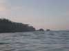
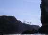
 Can we fit through this arch in Cape Elizabeth?
Taken on 2006-08-12 .
Links to related images: Date. Proofs. Map. Story.
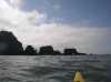
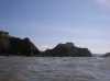
 Rounding Cape Elizabeth in choppy water
Taken on 2006-08-12 .
Links to related images: Date. Proofs. Map. Story.
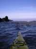
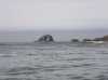
 Approaching Point Grenville
Taken on 2006-08-12 .
Links to related images: Date. Proofs. Map. Story.


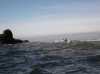
 We paddled through a rock garden off Point Grenville
Taken on 2006-08-12 .
Links to related images: Date. Proofs. Map. Story.
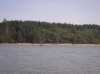
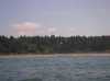
 Sandy beach in the middle of Point Grenville
Taken on 2006-08-12 .
Links to related images: Date. Proofs. Map. Story.

 We paddled through a rock garden off Point Grenville
Taken on 2006-08-12 .
Links to related images: Date. Proofs. Map. Story.
 We missed the Grenville Arch by going so close to shore
Taken on 2006-08-12 .
Links to related images: Date. Proofs. Map. Story.

 Once inside Point Grenville there were cars and kids on the beach
Taken on 2006-08-12 .
Links to related images: Date. Proofs. Map. Story.
 House with observatory dome on Grenville Bay
Taken on 2006-08-12 .
Links to related images: Date. Proofs. Map. Story.
All text and images Copyright © 2006 by Mike Higgins / contact