Ever since I read an article about Brooks Island I have wanted to land there. This is a "lost" island in San Francisco Bay that is not well known. I paddled around the island once but did not land on it because it is a bird sanctuary and because a permit from the regional parks department is required to land. I called the parks department one weekend and tried to do this, but they inserted layers of Byzantine bureaucratic rules into the process. You have to go to the island during a time when the tides are at least 2 feet above the mean low. You have to reserve at least a week in advance for them to process the paperwork. It costs $5 per head to get a permit but they will not issue a permit for fewer than five people at a time. All these regulations meant that Marty and I could not just decide to go to the island on the spur of the moment when the tides and the wind were right. Finally, I scheduled a trip out to the island as a BASK initiated trip and collected the names of 17 people who were interested in coming along.
The weather had been very windy most of the week leading up to my scheduled time to land on Brooks Island. Since it was a mild paddle in the bay, most of it behind the Richmond Harbor Breakwater, I had billed it as an easy paddle suitable for beginners. On Saturday I paddled up the Carquinez Strait with Don Flemming and we had incredible winds. The prediction for Sunday was for 25 knot winds in the afternoon with gusts to 30. The island is less than 4 kilometers from Kellers Beach where I planned to launch. I was willing to fight a strong wind to satisfy my curiosity, but some of the beginner paddlers might be overwhelmed by the wind and resulting waves. So I arrived early and drove around the neighborhood downwind from Brooks Island. I found the public boat ramp in the Richmond Marina and later shuttled my car there. This was our emergency escape route: If the wind was too strong for anybody, we would land here instead of fighting the prevailing wind back to Kellers Beach.
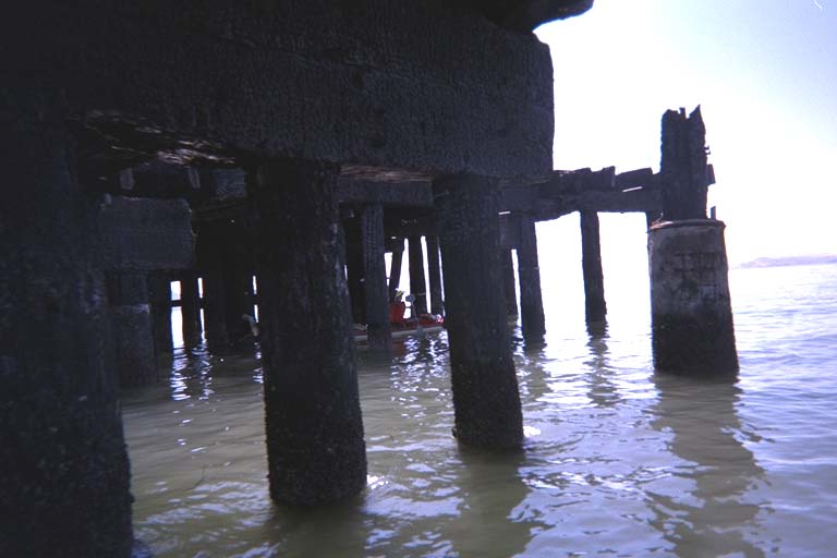
I bought a pass for fifteen people, then let seventeen people sign up. As I figured, several people canceled at the last minute and a few people just didn't show up. We ended up with only 13 people doing the trip. We launched a little after 11:00 PM from Keller Beach and headed around Richmond Point. Sort of like a normal BASK trip, the bulk of people started paddling point-to-point across the water towards the end of the old railroad pier when I would have hugged the shore and gone under the pier. Lagging behind to talk to a few friends, I cut across to the base of the pier and went under. A few people followed me and we ended up way ahead of the pack, who didn't know what hit them.
As we started up the harbor channel, we saw a hundred little sailboats crossing over from the marina. We were apparently witnessing some sort of race and worried about getting in the way. But by hugging the north side of the channel we stayed out of the way and crossed the inner harbor channel while they were turning around near the breakwater. A little farther down the channel we cut across to the Brooks Island side without encountering any more traffic.
We paddled up the old section of the breakwater, which looks like a sand spit extending from Brooks Island. There was a large noisy colony of terns nesting next to a little lagoon in the spit. We probably would have given them a wide berth out of politeness, but a row of floats a hundred yards offshore indicated this was a bird sanctuary and warned us to stay away from the colony. Then we landed on a little curve of sandy beach where the breakwater met the island. The resident ranger came down and told us this was not the normal landing spot but we were probably OK. The problem with this landing spot was the shallow water which exposes acres of mud at low tide. But the tide would not be going all the way out until after dark. The normal landing site was several hundred meters down the spit, on the other side of the tern colony. We would have had to walk past them on the south side of the spit. I think our shallow water landing was less stressful on the birds.
The "resident ranger" actually wasn't a real ranger. He (Fred) says that he is an independent contractor for the parks department. I have heard that becoming a real park ranger involves a difficult curriculum, there is a lot of competition to get a job as a ranger, and then you spend the rest of your career cleaning out pit toilets. Being and independent contractor for the parks department apparently means you don't have to clean out the toilets, so this sounds like the correct career path to me.
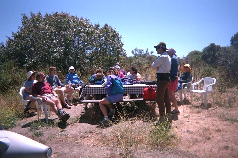
We all sat down for lunch while Fred and his wife gave us several different short talks about the island. One topic was the Ohlone Indians who used to live on the island and left a large midden shell pile on the north side. Another topic was the beginnings of western contact with the island, which is surprisingly vague already. Even the origin of the name of the island is not clear. The strongest contender is an army investigator (named Brooks) who came through The Bay searching for a missing shipment of gold intended for Sutters Fort before California was even a state. Mister Brooks hypothesized that the boat may have been blown off course to this island, but failed to find any trace of it. (A few years later a few crew members from the missing boat showed up in New York City, living the good life). Mister Brooks may (or may not) have returned to San Francisco Bay and may (or may not) have lived on the island for after he retired. Another topic of discussion was the recent (and better documented) history of the island. Almost half of the island was quarried away for various projects around the bay, including early versions of the breakwater in front of the Richmond Harbor. We hiked up to the top of the island (Fred insisted that every visitor MUST do this) and looked down into a crater 100 feet deep that used to slope down to 60 foot cliffs on the south side of the island. The actual original shape of the island is one of the bits of data that have been lost in antiquity.
Most of the BASKers left the island after the official talk and walk on the island. Some people had appointments in the afternoon, and others were worried about the wind picking up and making a later return difficult. Only four of us stayed behind to try and hike around the island. We walked counter-clockwise around the island from the spit and along the south shore where there used to be a 60 foot cliff. There were a few quarry ponds here that were filled with fresh water from natural springs. This water supply was used by the Ohlone Indians living here, but was currently quarantined because of high bacteria count. Fred carries water from the mainland by boat. In the middle of nowhere in the middle of this area we found a rickety old picnic table and two garbage cans. Does the county really maintain a picnic spot here? Or did someone construct this tableau out of driftwood and 50 gallon drums as an "art installation"?
It turns out that hiking all the way around was not possible. The trail around the west side of the island was closed in the spring for the egrets and great blue herons who nest in the trees there. Two springs ago during the heron nesting season the trail became overgrown with brambles and was never cleared. Fred tried to fight his way though this trail recently and still had scars to show for it. We took his advice and didn't even try. Instead we tried to find the trail up the ridge to the "peak" of the island where we had been earlier. The official map of the island shows a trail here but it is apparently rarely used. We followed the ridge (actually the edge of the crater) and scrambled through the grass and brush. On the way up we saw lots of little tiny trails in the grass. Fred's wife had pointed these out to me earlier and told us that these were made by a native American rodent. This is an animal that looks like a little hamster. It sort of burrows trails at the base of the grass, but never actually gets underground like a gopher. As we neared the top of the island again, I saw a streak of something move down one of these trails. I tried to point it out to my companions but it moved so fast through the trails I could not even tell what color it was. Nobody else even saw it. It zigged and zagged through the trails and disappeared into an area of thick grass where we I could not see it any more.
We walked back down the trail past the ranger's residence and back to our kayaks. Looking down at the water, we could see whitecaps across the bay and riffled water in the channel. But there was a narrow wind shadow behind the breakwater with still looking water. We paddled as close as possible down the breakwater to try to stay in this spot out of the wind. I'm not sure how successful this strategy was because the wind died down before we got to the end of the breakwater. We paddled across to the railroad pier and under the base of it (without going the long way around). By the time we paddled back for our landing at Kellers Beach the air was dead calm and we had perfect weather.