I talked Dan Koenig into picking me up after this run, so I only had to go one way, and I easily did the last 6 miles of Sea Ranch in one morning. Shell beach is 0.6 miles from the parking lot, but it is a beautiful beach and worth the walk. I slid the kayak over the grassy, muddy trail most of the way, and only had to carry it over one road and down the last dozen meters of the trail, which is a gravel road leading almost down to the sand. The water was so calm I just walked out into the water and sat down in the kayak. The tide was rising and peaked while I was out, and the Weather Service reported 3 foot swells, so the ocean was calm and I got to do almost all the exploring around rocks that I wanted to do.
Just north of shell beach is another small sandy beach that has no access, and which might be a fun place to stop one day. I quickly made it to Walk-On Beach Trailhead, one mile north of Shell Beach. There is a sandy beach here, and a set of access stairs, but I didn't stop. The name of this beach comes from the trail, which leads from here along the top of the bluff all the way up to Gualala Point Park, a 3.5 mile hike that looks like it would be a nice short walk. It's unclear from the map, but I think that the trail loops back part way, so you could do the round trip without seeing too much of the same trail twice. I took it easy for most of the trip, and managed to avoid going the hard way around most of the rocks close to the cliffs. One time I got sort of stuck, where it was too rough close to shore to continue, but too rough to turn out to sea. I could have turned back, but instead headed out over a spot I had seen some breakers. It turned out that this was a very shallow spot with submerged rocks, and a wave came and broke in front of me. I got wet, but made it over the wave. I suppose one reason I got in trouble here was because the whole trip, the water was so clear I often caught glimpses of the bottom. The water was a beautiful blue- green color, and I could see kelp fronds hanging meters down into it. When waves broke close to the cliffs, the white foam would mix with the color of the water and make wonderful electric blues. The first dozen or so times I saw a rock go under me, I had a panic reaction: Seeing a rock under less clear situations usually means that I'm right on top of it, the water is shallow, and either I'm going to hit it in the next trough and get knocked off, or the next wave is going to break over it and knock me off.
I stopped in a calm spot to eat my snack and drink and re-arranged things in my dry-sack. This was the first trip that I took along a dry-sack, and I had a big beach towel, a pair of sandals, a clean pair of pants, a shirt, a cable and combination lock for securing the kayak if I have to leave it, my usual emergency kit, and some food and drink. All this didn't fill up half of a dry-sack that was designed to hold a rolled up sleeping pad. But the lid just rolled down a few more times to take up the slack, and the sack fit snugly strapped down in the cargo slot behind the seat. I had to re-arrange things because I had left my sun-screen in the emergency kit in the bottom of the sack.
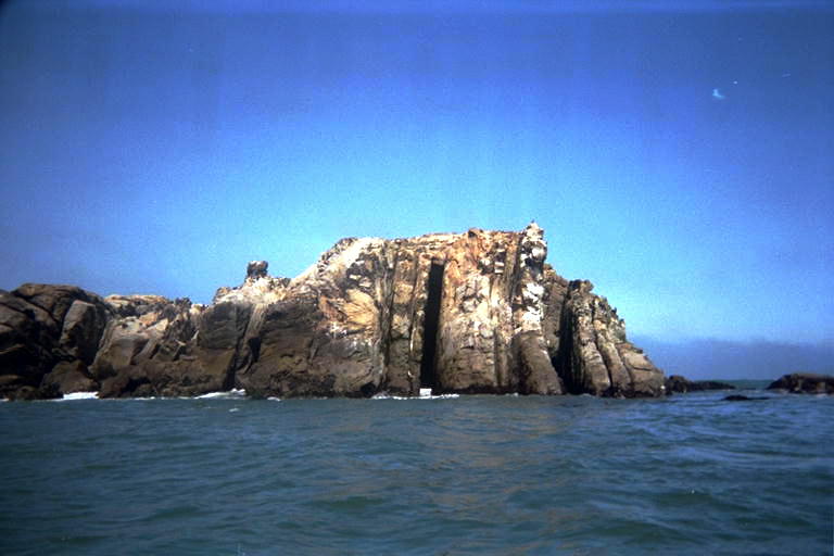
There was a place on my Sea Ranch Map from the county, (I copied a section of it by hand and did not bring the original) where a few really tiny little coves were drawn in. One of them was drawn as if it had a narrow entrance that opened up to a larger body of water. The trail was shown jogging around this little micro-bay. So when I got to this part of the trip, I nosed into every crack in the cliff, trying to find it. What I found were several little dents in the cliff, some of which had sandy beaches on the end of them. I think the map-maker exaggerated one of these, but they were too shallow and rough to allow me to go in. I think I'll get the USGS map for this area and compare it to the county park map. One reason why I feel the need for a more accurate map was a large omission in the county map: a large rock (or small island) offshore from Gualala Point. This rock was made of layers that had been turned on edge, and then some of the layers had eroded faster than others. The result were some impressive vertical walls, and rectangular channels into the rock with water surging in and out. This is probably the same type of formation that made up the little dents in the shore I had just passed. When I was far from the rock, the water looked calm around it, but by the time I got there, the waves were pretty intimidating. I think I got there just as the tide turned, and it was especially rough just for me. The waves intimidated me from trying to paddle into the rectangular channels, but most of them were too narrow to get into anyway. But then I got to the seaward side of the rock, there was a row of large smooth rocks, probably the tattered remains of a vertical wall that the ocean had worn into separate pieces, like a row of giant teeth, 3 meters apart. I turned and went between the last two of these into a channel closer to the bulk of the rock. The currents were weird, going in directions that I wouldn't have thought possible (like left to right between the two teeth I was traveling between). But out in the deep water here, the waves were not breaking, so I felt in reasonable control.
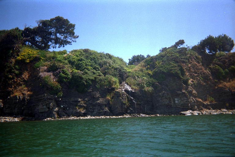
Around the next point, I was suddenly at the beach at Gualala Point. This is a large white sandy beach, with mild waves (today) that allowed me to paddle close to shore and enjoy the sound of the surf. I probably could have landed anywhere and walked over the sand to the Gualala River, but I went all the way down the beach so I could honestly say I had made it to Mendocino County. Then I turned back and crash- landed on the beach near the mouth of the river. Wet again, but I appreciated being cooled off on this warm calm day. I slid the kayak over the narrow spit here, and stepped into the calm river water. The act of sitting down in the kayak here, with the smell of my sunscreen in my nostrils, evoked a strong memory of childhood trips to the Russian River, sitting down in an inner-tube. It occurred to me that since it's maiden voyage from the boat ramp at Jenner, this kayak has not been in calm river water: All the miles have been put in on the ocean. I expected an easy trip up the river to the Gualala Point Visitors center, but was surprised by a strong current going downstream. I should have thought of this, since the Russian River is still swollen and running fast with leftover flood water. But I was able to paddle against it if I stayed in the deep parts where my paddle didn't strike bottom and mess up my strokes.
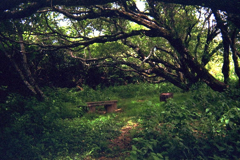
I could see a building that I assumed (correctly) was the visitors center, and I wanted to get there to meet Dan to pick me up. But it turned out that there was a cliff on the south side of the river, and the visitors center was quite a way off the gound. Should I land on the spit and walk around looking for the beach trail? Or go up river another half a mile and hope for a trail through the trees? I decided to keep paddling: I was early, and if there was no trail, the trip back down with the current would be an easy one. It was impossible to see trails because the greenery was so thick, but there was a place where it looked like the gound cover had been worn away near the edge of a terrace near the river. This was just below where the visitors center was (which I could no longer see) and I thought this might be the edge of a trail and stopped here to look around. The terrace turned out to be a beautiful little glen, 2 meters higher than the river, with picnic tables and bar-b-que equipment. There was a row of trees on the edge of the river, ferns and other greenery on the cliff side, foxtails and some kind of leafy gound cover everywhere. It was a beautiful spot, and of course it had steps and a trail leading up. I pulled the kayak up by the remains of the picnic table. Actually, the floods had taken the table away, and all that remained were two sturdy benches. I took off my wetsuit, and put on dry clothes from my dry-sack. Walking up the trail to the visitors center, as I got within earshot of the parking lot, I heard the familiar sound of my VW bus arriving. I had left it at Shell Beach with a key hidden in a pre-arranged place. Dan got to sleep in late, (my alarm went of at 6:00am) drove up and swapped cars, and was arriving exactly at the same time I did. He had brought a picnic lunch, so we went back down to eat it in the beautiful green glen before we headed back.
So this was it! I have now paddled past every inch of the coast of Sonoma County! What will I do next? Well, there's still the parts of Marin County around Point Reyes that I want to finish. And I want to go back to all my favorite places and take pictures for this Word Wide Web document. And I especially want to go past Fisk Mill Cove and find that obelisk again! I also intend to start fishing from the kayak one day soon, so it is unlikely that it will sit around idle.
Highway 1 was washed out north of Jenner, and the detour took me up the hills and down the Myers Grade Road (12% grade) on the way home. The air was so clear as I came over the top that I could see farther south than I ever recall seeing. Below me was Jenner Beach and Goat Rock. Been there, done that. Raising my eyes, the next recognizable beach is Salmon Creek Beach, and Mussel point at the tip of Bodega head. Done that also. A squint through the haze, and I could make out Tomales Bay, which Marty and I explored together. But there was still this huge expanse of land sticking farther and farther out to sea from Tomales Bay: Point Reyes. Going there next.