The following images were all taken near the same location, ~38.648868982333/123.40099096298:
Click on the small images to see the full-sized ones.
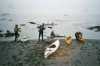
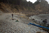
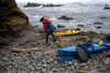
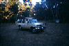
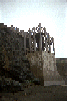
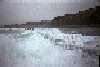
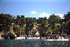
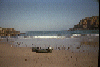
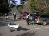 Collecting gear at the Stengel Beach parking lot
Taken on 2007-11-24 .
Links to related images: Date. Proofs. Map. Story.
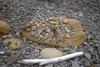
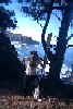
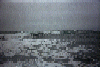
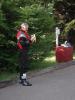 Dave Littlejohn carbo-loading before kayaking
Taken on 2007-11-24 .
Links to related images: Date. Proofs. Map. Story.
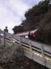
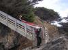
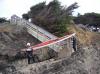
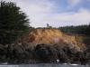
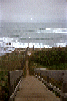
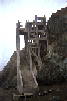
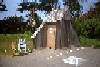
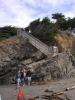 The beautiful access stairs/sculpture at Stengel Beach
Taken on 2007-11-24 .
Links to related images: Date. Proofs. Map. Story.
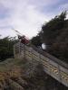
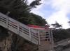
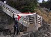
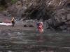
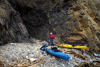
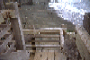
 The Stengel Beach access is not set up for kayaks
Taken on 2007-11-24 .
Links to related images: Date. Proofs. Map. Story.
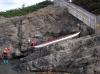
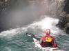
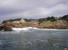
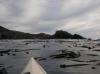
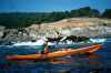
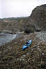
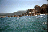
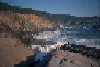
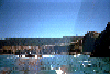
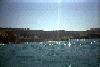
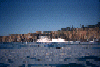
 Launching from Stengel Beach
Taken on 2007-11-24 .
Links to related images: Date. Proofs. Map. Story.
 A photograph of a photographer photographing kayaks launching at Stengel Beach
Taken on 2007-11-24 .
Links to related images: Date. Proofs. Map. Story.
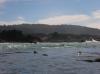
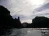
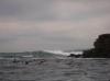
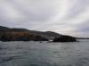
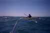
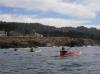 John Somers, Ruth Cooper and Don Fleming paddling south from Stengel Beach
Taken on 2007-11-24 .
Links to related images: Date. Proofs. Map. Story.
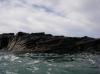
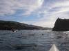
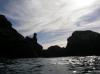
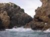
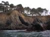
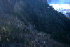
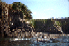
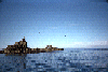
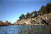
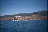
 Beautiful offshore rocks south from Stengel Beach
Taken on 2007-11-24 .
Links to related images: Date. Proofs. Map. Story.
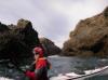
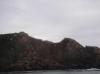
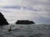 John Somers likes to go behind the offshore rocks
Taken on 2007-11-24 .
Links to related images: Date. Proofs. Map. Story.
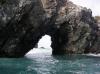
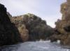
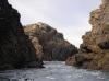
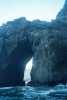
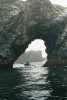
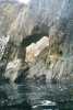
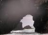 I have been through this arch on calmer days
Taken on 2007-11-24 .
Links to related images: Date. Proofs. Map. Story.
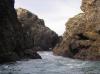
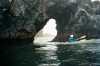
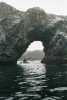
 The arch closes out on John Somers
Taken on 2007-11-24 .
Links to related images: Date. Proofs. Map. Story.
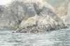
 A slot in Black Point, can a kayak fit through there?
Taken on 2007-11-24 .
Links to related images: Date. Proofs. Map. Story.
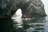
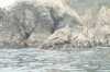
 John Somers paddling out the Black Point slot
Taken on 2007-11-24 .
Links to related images: Date. Proofs. Map. Story.
 D�rte Mann paddling out the Black Point slot
Taken on 2007-11-24 .
Links to related images: Date. Proofs. Map. Story.
 Dave Littlejohn paddling out the Black Point slot
Taken on 2007-11-24 .
Links to related images: Date. Proofs. Map. Story.
 John Somers side surfing over a washover at Black Point
Taken on 2007-11-24 .
Links to related images: Date. Proofs. Map. Story.
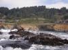
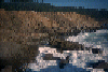
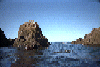
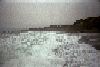
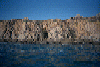
 The large waves breaking outside the rocks at Black Point
Taken on 2007-11-24 .
Links to related images: Date. Proofs. Map. Story.
 Launchin after lunch in Fishermans Bay
Taken on 2007-11-24 .
Links to related images: Date. Proofs. Map. Story.
 Beautiful rock formations in Fishermans Bay
Taken on 2007-11-24 .
Links to related images: Date. Proofs. Map. Story.
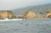
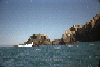
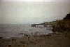
 False Rocky Point
Taken on 2007-11-24 .
Links to related images: Date. Proofs. Map. Story.
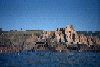
 The true Rocky Point
Taken on 2007-11-24 .
Links to related images: Date. Proofs. Map. Story.
 Horseshoe Point
Taken on 2007-11-24 .
Links to related images: Date. Proofs. Map. Story.

 Arches and rocks south of Pebble Beach Sea Ranch
Taken on 2002-07-13 .
Links to related images: Date. Proofs. Map. Story.
 BASKers ready to launch from Pebble Beach at Sea Ranch
Taken on 2002-07-13 .
Links to related images: Date. Proofs. Map. Story.
 Everyone had to go through this litle arch south of Pebble Beach Sea Ranch
Taken on 2002-07-13 .
Links to related images: Date. Proofs. Map. Story.
 Rocks south of Sea Ranch
Taken on 2002-07-13 .
Links to related images: Date. Proofs. Map. Story.
 Hole in the rock south of Sea Ranch
Taken on 2002-07-13 .
Links to related images: Date. Proofs. Map. Story.
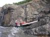
 Fuzzy landing at Stewarts Point
Taken on 2002-07-13 .
Links to related images: Date. Proofs. Map. Story.
 Looking back at Stewarts Point
Taken on 2002-07-13 .
Links to related images: Date. Proofs. Map. Story.
 Maryly Snow south of Stewarts Point
Taken on 2002-07-13 .
Links to related images: Date. Proofs. Map. Story.
 Ken Kelton and I stop at Fisk Mill cove while on a
kayak camping trip.
Ken Kelton and I stop at Fisk Mill cove while on a
kayak camping trip.
Taken on 1998-09-17 .
Links to related images: Date. Proofs. Map. Story.
 Ken Kelton and I stop at Rocky Point while on a
kayak camping trip.
Ken Kelton and I stop at Rocky Point while on a
kayak camping trip.
Taken on 1998-09-17 .
Links to related images: Date. Proofs. Map. Story.
 Ken and I 'ninja camping' near Stuarts Point in a crack in the cliff
Taken on 1998-09-17 .
Links to related images: Date. Proofs. Map. Story.
 shoreline
Taken on 1997-07-20 .
Links to related images: Date. Proofs. Map. Story.
 kayak n/shore
Taken on 1997-07-20 .
Links to related images: Date. Proofs. Map. Story.
 crack in rock
Taken on 1997-07-20 .
Links to related images: Date. Proofs. Map. Story.
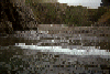
 water around rock
Taken on 1997-07-20 .
Links to related images: Date. Proofs. Map. Story.
 mild water b/rocks
Taken on 1997-07-20 .
Links to related images: Date. Proofs. Map. Story.
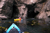
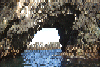
 view out cave
Taken on 1997-07-20 .
Links to related images: Date. Proofs. Map. Story.
 kayaks n/arch
Taken on 1997-07-20 .
Links to related images: Date. Proofs. Map. Story.
 kayaks b/rocks
Taken on 1997-07-20 .
Links to related images: Date. Proofs. Map. Story.
 kayaks t/arch
Taken on 1997-07-20 .
Links to related images: Date. Proofs. Map. Story.
 kayak b/rock
Taken on 1997-07-20 .
Links to related images: Date. Proofs. Map. Story.
 Leigh in cove
Taken on 1997-07-20 .
Links to related images: Date. Proofs. Map. Story.
 kayak enter arch
Taken on 1997-07-20 .
Links to related images: Date. Proofs. Map. Story.
 barn
barn
Taken on 1997-07-20 .
Links to related images: Date. Proofs. Map. Story.
 caves
caves
Taken on 1997-07-20 .
Links to related images: Date. Proofs. Map. Story.
 cave
cave
Taken on 1997-07-20 .
Links to related images: Date. Proofs. Map. Story.
 campers beach
Taken on 1997-07-20 .
Links to related images: Date. Proofs. Map. Story.
 I met Peter while out on the water. He was also kayaking while a friend
went d
I met Peter while out on the water. He was also kayaking while a friend
went d
Taken on 1996-03-17 .
Links to related images: Date. Map. Story.
 Point north of Fisk Mill Cove
Taken on 1996-02-11 .
Links to related images: Date. Proofs. Map. Story.
 Fisk Mill Cove distant
Taken on 1996-02-11 .
Links to related images: Date. Map. Story.
 Sentinal Rock from below. Notice the deck, accessable by a trail.
Taken on 1996-02-11 .
Links to related images: Date. Proofs. Map. Story.
 Fisk Mill cove viewed from the water
Taken on 1996-02-11 .
Links to related images: Date. Proofs. Map. Story.
 Red lichen on rock looks like blood at Horseshoe Cove.
Taken on 1996-02-11 .
Links to related images: Date. Proofs. Map. Story.
 The tip of the point just south of Horseshoe Cove.
Taken on 1996-02-11 .
Links to related images: Date. Proofs. Map. Story.
 Back to the top of the cliff with the recovered paddle.
Taken on 1996-02-11 .
Links to related images: Date. Proofs. Map. Story.

 Me climbing back up with the recovered paddle
Taken on 1996-02-11 .
Links to related images: Date. Proofs. Map. Story.

 Dad's feet looking down at me climing to Horseshoe Cove
Taken on 1996-02-11 .
Links to related images: Date. Proofs. Map. Story.
 Me climbing down to the beach at Horseshoe Cove
Taken on 1996-02-11 .
Links to related images: Date. Proofs. Map. Story.
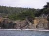
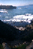
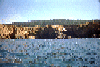
 A view of the ranch over Fishermans Bay to the north
Taken on 1996-02-11 .
Links to related images: Date. Proofs. Map. Story.
 But first some images approaching Rock Point from the south:
Taken on 1996-02-11 .
Links to related images: Date. Proofs. Map. Story.
 Pictures of the beach inside the cove created by the point:
Taken on 1996-02-11 .
Links to related images: Date. Proofs. Map. Story.
 Rocky point
Taken on 1996-02-11 .
Links to related images: Date. Proofs. Map. Story.
 The chariot of Joe Toback who gave me a ride back to my car after my shipwreck.
Taken on 1996-02-11 .
Links to related images: Date. Map. Story.
 Shipwrecked (or is it kayak-wrecked) in Hoseshoe Cove.
Taken on 1996-02-11 .
Links to related images: Date. Proofs. Map. Story.
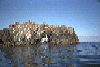
 Cormerants on rock in Horseshoe Cove
Taken on 1996-02-11 .
Links to related images: Date. Proofs. Map. Story.
 And the beach viewed from out at sea.
Taken on 1995-06-10 .
Links to related images: Date. Proofs. Map. Story.
 The beach in the far corner of the bay.
Taken on 1995-06-10 .
Links to related images: Date. Proofs. Map. Story.
 Any gap in the rocks, I went through there.
Taken on 1995-06-10 .
Links to related images: Date. Proofs. Map. Story.
 I think the buildings are part of a still functioning ranch.
Taken on 1995-06-10 .
Links to related images: Date. Proofs. Map. Story.
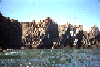
 Calm water and beautiful bluffs in Fishermans Cove
Taken on 1995-06-10 .
Links to related images: Date. Proofs. Map. Story.
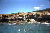
 Looking back out of Fishermans Cove
Taken on 1995-06-10 .
Links to related images: Date. Proofs. Map. Story.
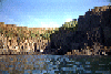
 Coastline near Fishermans Cove
Taken on 1995-06-10 .
Links to related images: Date. Proofs. Map. Story.
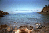
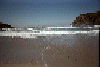
 Mild waves approaching Sea Ranch Pebble Beach
Taken on 1995-06-10 .
Links to related images: Date. Proofs. Map. Story.
 Cliffs south of Sea Ranch
Taken on 1995-06-10 .
Links to related images: Date. Proofs. Map. Story.
 Ready to launch at Sea Ranch Pebble Beach
Taken on 1995-06-10 .
Links to related images: Date. Proofs. Map. Story.
 Stewarts Point
Taken on 1995-06-10 .
Links to related images: Date. Proofs. Map. Story.
 You can't tell in this picture, but there is the ruins of anold set of stairs
Taken on 1995-05-28 .
Links to related images: Date. Proofs. Map. Story.
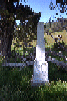
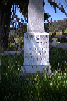
 A picture of the obelisk. My next camera will have a zoom feature!.
Taken on 1995-05-28 .
Links to related images: Date. Proofs. Map. Story.
 Here is what the obelisk looks like from the water. In the center ofthese pic
Taken on 1995-05-28 .
Links to related images: Date. Proofs. Map. Story.
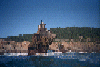
 Horseshoe Cove in Salt Point State Park
Taken on 1995-05-28 .
Links to related images: Date. Proofs. Map. Story.
 ,
I highly recommend the walk.
,
I highly recommend the walk.
Taken on 1995-03-26 .
Links to related images: Date. Proofs. Map. Story.
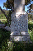
 The Obelisk at Fisk Mill Cove
Taken on 1995-03-26 .
Links to related images: Date. Proofs. Map. Story.
 Looking up at Sentinal Rock from the stairs at Fisk Mill Cove
Taken on 1995-03-26 .
Links to related images: Date. Proofs. Map. Story.
 Sentinal Rock doesn't look so steep from the other side of Fisk Mill Cove
Taken on 1995-03-26 .
Links to related images: Date. Proofs. Map. Story.
 Clara Bell, lived less than 4 months according to the Fisk Mill Obelisk
Taken on 1995-03-26 .
Links to related images: Date. Proofs. Map. Story.
 Andrew J. Fisk, died only days before his (?)daughter
Taken on 1995-03-26 .
Links to related images: Date. Proofs. Map. Story.

 The view back under that arch towards shore:
Taken on 1995-02-25 .
Links to related images: Date. Proofs. Map. Story.
 Another arch, large enough to go under:
Taken on 1995-02-25 .
Links to related images: Date. Proofs. Map. Story.

 A small arch close to shore.
Taken on 1995-02-25 .
Links to related images: Date. Proofs. Map. Story.
 Looking out past the arched rock
Taken on 1995-02-25 .
Links to related images: Date. Proofs. Map. Story.
 Black Point Beach, Sea Ranch
Taken on 1995-02-25 .
Links to related images: Date. Proofs. Map. Story.
 I have a bunch of pictures of Sea Ranch houses taken from the sea
Taken on 1995-02-25 .
Links to related images: Date. Proofs. Map. Story.
 I have a bunch of pictures of Sea Ranch houses taken from the sea
that will b
I have a bunch of pictures of Sea Ranch houses taken from the sea
that will b
Taken on 1995-02-25 .
Links to related images: Date. Proofs. Map. Story.
 Black Point from the south
Taken on 1995-02-25 .
Links to related images: Date. Proofs. Map. Story.

 while trying to make a landing.
Taken on 1995-02-12 .
Links to related images: Date. Proofs. Map. Story.
 And some views from a safe distance out to sea:
Taken on 1995-02-12 .
Links to related images: Date. Proofs. Map. Story.
 while trying to make a landing.
Taken on 1995-02-12 .
Links to related images: Date. Proofs. Map. Story.
 And some views from a safe distance out to sea:
Taken on 1995-02-12 .
Links to related images: Date. Proofs. Map. Story.
 while trying to make a landing.
Taken on 1995-02-12 .
Links to related images: Date. Proofs. Map. Story.

 Two views back out the cove from inside
Taken on 1995-02-12 .
Links to related images: Date. Proofs. Map. Story.
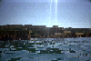
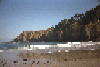
 Sea Ranch Pebble Beach on a mild overcast day
Taken on 1994-11-15 .
Links to related images: Date. Proofs. Map. Story.
 Stump Beach on a big scary wave day
Taken on 1994-10-13 .
Links to related images: Date. Proofs. Map. Story.

 From outside it doesn't look as scary
Taken on 1994-10-13 .
Links to related images: Date. Proofs. Map. Story.
 I have a bunch of pictures of Sea Ranch houses taken from the sea
that will b
I have a bunch of pictures of Sea Ranch houses taken from the sea
that will b
Taken on ~1994 .
Links to related images: Date. Proofs. Map.
 But first some images approaching Rock Point from the south:
Taken on ~1994 .
Links to related images: Date. Proofs. Map.
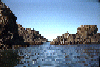
 Some incredible rock castles north of Rocky Point:
Taken on ~1994 .
Links to related images: Date. Proofs. Map.

 Pictures of the beach inside the cove created by the point:
Taken on ~1994 .
Links to related images: Date. Proofs. Map.
 But first some images approaching Rock Point from the south:
Taken on ~1994 .
Links to related images: Date. Proofs. Map.
 For me, this image tells it all about the Sea Ranch public beach access.
Sea
For me, this image tells it all about the Sea Ranch public beach access.
Sea
Taken on ~1994 .
Links to related images: Date. Proofs. Map.
 Stump Beach on a mild sunny day
Taken on ~1994 .
Links to related images: Date. Proofs. Map.
All text and images Copyright © by Mike Higgins / contact